Au cœur du Rann de Kutch, ce désert de sel éblouissant qui borde la frontière entre l'Inde et le Pakistan, une île aride et oubliée garde le souvenir de l'une des plus grandes aventures urbaines de la préhistoirePréhistoireEnsemble des périodes de l'histoire humaine antérieures à l'écriture, du PaléolithiquePaléolithiquePériode la plus ancienne et la plus longue de la préhistoire (env. −3,3 Ma à −12 000), définie par les outils de pierre taillée et un mode de vie de chasse et de cueillette.→ à l'âge des métaux, connues principalement par les vestiges matériels.→ tardive. Sur l'île de Khadir, dans l'État indien du Gujarat, les ruines de Dholavira dressent encore leurs murailles de pierre au-dessus d'un paysage que l'on dirait inhospitalier au point d'interdire toute vie. Et pourtant, pendant près de quinze siècles, une cité prospère y a battu son plein, comptant peut-être plusieurs milliers d'habitants, ceinte de remparts, irriguée par un réseau d'eau d'une ingéniosité stupéfiante. Dholavira est aujourd'hui considérée comme l'un des sites les mieux conservés de la civilisation de l'IndusCivilisation de l'IndusGrande civilisation urbaine de l'âge du bronze (~2600-1900 av. J.-C.) sur l'actuel Pakistan et le nord-ouest de l'Inde : villes planifiées (HarappaHarappaCité majeure de la civilisation de l'Indus, dans le Pendjab pakistanais, premier site fouillé qui a donné son nom à la culture harappéenne.→, Mohenjo-daroMohenjo-daroL'une des plus grandes villes de la civilisation de l'Indus (Sind, Pakistan), célèbre pour sa Grande Baignoire et son urbanisme en damier ; site du patrimoine mondial.→), briques standardisées, écriture non déchiffrée, absence de palais monumentaux.→, et son inscription sur la liste du patrimoine mondial de l'UNESCO en 2021 est venue consacrer son importance exceptionnelle [1].
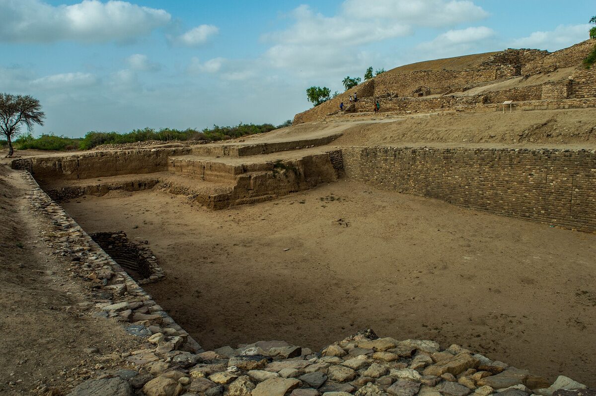
Ce qui frappe d'emblée le visiteur, c'est le contraste entre la rudesse du milieu et le raffinement de l'organisation urbaine. Là où l'on s'attendrait à trouver les vestiges fragiles d'un campement de fortune, on découvre une ville pensée dans ses moindres détails : des enceintes concentriques, une citadelle dominante, des quartiers tracés avec rigueur, des systèmes de drainage, et surtout cette obsession de l'eau qui irrigue toute l'histoire du site. Dholavira n'est pas seulement un site archéologique de plus dans le grand catalogue de la civilisation harappéenne : c'est un laboratoire grandeur nature de l'adaptation humaine à un climat extrême, un témoignage de ce que des sociétés de l'âge du bronzeÂge du bronzePériode protohistorique succédant au NéolithiqueNéolithique« Âge de la pierre nouvelle » : période marquée par l'agriculture, l'élevage, la sédentarisation et la céramique, à partir d'env. −10 000.→, marquée par la métallurgieMétallurgieEnsemble des techniques d'extraction et de travail des métaux (cuivre, bronze, or) ; son essor à l'énéolithique et à l'âge du bronze transforme outillage, armement et hiérarchies sociales.→ du bronze (alliage cuivre-étain) et l'essor des premières cités et États ; en Égypte, elle correspond à l'époque des premières pyramides.→ pouvaient accomplir face à la rareté de la ressource la plus vitale [2].
Au fil de cet article, nous explorerons la géographie singulière de l'île de Khadir et les raisons pour lesquelles une cité a pu y naître ; l'histoire de la découverte du site et des fouilles qui en ont révélé la richesse ; les sept phases d'occupation qui scandent quinze siècles d'histoire ; l'urbanismeUrbanismeOrganisation planifiée de l'espace urbain (rues, quartiers, réseaux d'eau et d'égouts, édifices publics) ; la civilisation de l'Indus en offre un exemple précoce et remarquable.→ tripartite si caractéristique de Dholavira ; le génie hydraulique qui en fait un cas d'école mondial ; le mystérieux « signboard » et l'écriture non déchiffrée de l'Indus ; la vie économique et artisanale de ses habitants ; les rites funéraires de sa nécropole ; enfin, le lent déclin de la ville sous l'effet conjugué de l'aridification et des bouleversements qui frappèrent l'ensemble de la civilisation de l'Indus.
Le site couvre une superficie d'environ quarante-sept hectares pour la zone fortifiée, ce qui en fait, par sa taille, le cinquième plus grand site harappéenHarappéenRelatif à la civilisation de l'Indus, du nom de son premier site fouillé, Harappa (Pendjab pakistanais) ; désigne la culture matérielle, l'écriture et les habitants de cette civilisation.→ connu, derrière Mohenjo-daro, Harappa, Ganweriwala et Rakhigarhi. Mais la taille n'est pas tout : c'est la qualité de conservation, l'usage massif de la pierre et la cohérence du plan d'ensemble qui confèrent à Dholavira son caractère exceptionnel. Là où d'autres cités ont été en partie dévorées par la récupération de leurs briques au fil des millénaires, ou ennoyées sous les alluvions, Dholavira a traversé le temps avec une netteté presque architecturale, offrant aux archéologues un plan lisible jusque dans ses moindres ruelles.
Une cité dans le désert
Pour comprendre Dholavira, il faut d'abord comprendre le lieu qui l'a vue naître. L'île de Khadir, ou Khadir Bet, est un affleurement rocheux d'environ 2 000 kilomètres carrés émergeant du Grand Rann de Kutch, cette immense étendue salée qui s'étire sur des milliers de kilomètres carrés au nord-ouest du sous-continent indien. Pendant la saison sèche, le Rann est un désert de sel craquelé, d'une blancheur aveuglante, balayé par les vents et la chaleur. Pendant la mousson, il se transforme partiellement en marécage saumâtre, isolant les îles rocheuses comme autant de radeaux de pierre. C'est sur l'angle nord-ouest de l'une de ces îles que les bâtisseurs harappéens ont choisi d'établir leur cité, à un endroit où deux cours d'eau saisonniers, le Manhar et le Mansar, encadrent un promontoire rocheux [2].
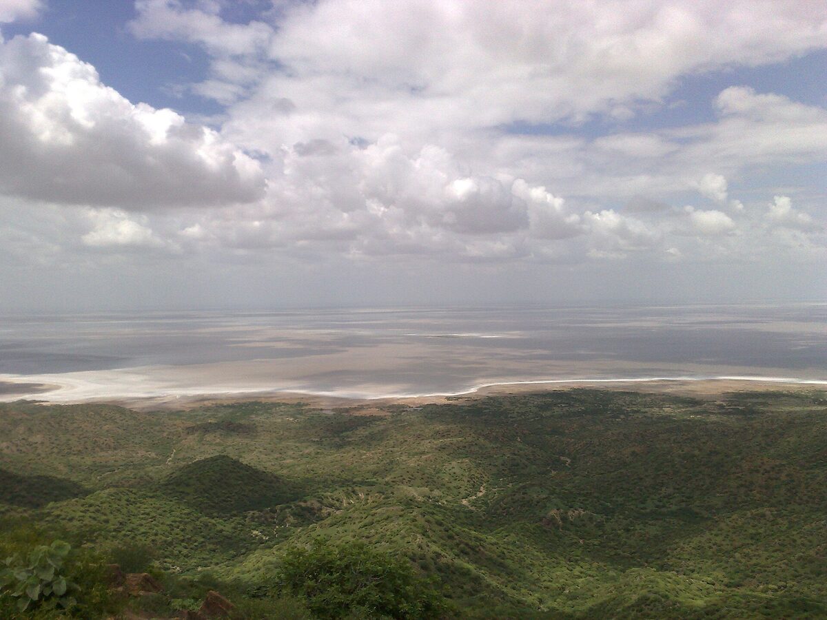
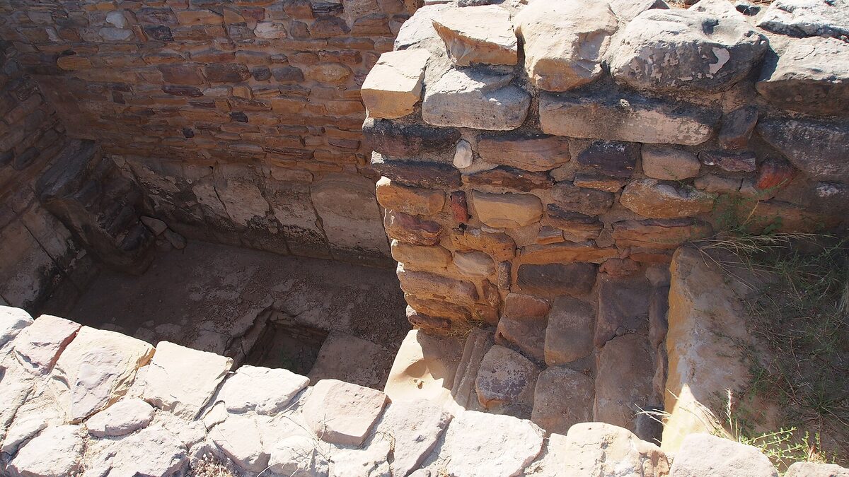
Ce choix d'implantation peut sembler paradoxal. Pourquoi fonder une ville dans un milieu aussi hostile, où l'eau douce est rare, où l'agricultureAgricultureCulture des plantes et production de nourriture par travail du sol, apparue au Néolithique au Proche-Orient puis indépendamment ailleurs ; elle transforme radicalement les sociétés humaines.→ semble impossible et où le sel imprègne jusqu'à la nappe phréatique ? La réponse tient à plusieurs facteurs convergents. D'abord, l'île offrait une matière première précieuse : une pierre locale, des grès et des calcaires faciles à extraire et à tailler, qui ont permis aux Harappéens de Dholavira de construire en pierre là où la plupart des autres cités de l'Indus, comme Mohenjo-daro ou Harappa, bâtissaient surtout en brique crue et cuite. Cette particularité explique en partie l'exceptionnel état de conservation du site.
Ensuite, et surtout, Dholavira occupait une position stratégique sur les routes commerciales. À l'époque de son apogée, le Rann de Kutch n'était pas le désert qu'il est devenu : il s'agissait probablement d'un golfe marin ou d'un vaste plan d'eau navigable, communiquant avec la mer d'Arabie. Dholavira contrôlait ainsi un point de passage entre l'intérieur du continent et les voies maritimes, entre les sources de matières premières du Gujarat, du Sind et du Rajasthan, et les marchés lointains de la Mésopotamie et du golfe Persique. La cité était un comptoir, un nœud d'échanges où transitaient coquillages, pierres semi-précieuses, cuivre et produits manufacturés [1].
Enfin, les bâtisseurs avaient identifié une ressource décisive : le ruissellement des deux ruisseaux saisonniers qui encadraient le site. Plutôt que de dépendre d'une rivière permanente, comme la plupart des grandes cités antiques, Dholavira allait fonder sa survie sur la capture, le stockage et la gestion de l'eau de pluie. C'est cette contrainte qui, paradoxalement, a engendré le génie hydraulique de la cité, faisant d'un handicap une signature architecturale.
Découverte et fouilles
Le site de Dholavira tire son nom d'un village moderne voisin. Localement, les ruines étaient connues sous le nom de Kotada Timba, « le grand monticule du fort », ce qui en dit long sur la mémoire populaire des lieux : les villageois savaient depuis longtemps que ces buttes recouvraient les restes d'une ville ancienne et fortifiée. C'est en 1967-1968 que l'archéologue indien Jagat Pati Joshi, de l'Archaeological Survey of India, identifia formellement le site comme appartenant à la civilisation de l'Indus, le portant à l'attention de la communauté scientifique [3].
Mais c'est à partir de 1989 que Dholavira allait livrer ses secrets les plus précieux, sous la direction d'un autre archéologue de l'ASI, Ravindra Singh Bisht. Pendant treize campagnes de fouilles, jusqu'en 2005, l'équipe de Bisht dégagea méthodiquement les structures de la ville, révélant son plan tripartite, ses réservoirs monumentaux, ses fortifications, et toute une série d'objets qui allaient bouleverser la compréhension de la civilisation de l'Indus. Ces fouilles révélèrent que Dholavira n'était pas un site mineur de la périphérie harappéenne, mais bien l'une des cités majeures du monde de l'Indus, comparable par son ampleur et son organisation aux grands centres que sont Mohenjo-daro, Harappa, Ganweriwala et Rakhigarhi [2].
Le travail de Bisht et de son équipe fut remarquable par sa rigueur stratigraphique. En distinguant soigneusement les couches successives d'occupation, les archéologues purent reconstituer une chronologie fine de la vie du site, depuis ses humbles débuts jusqu'à son abandon, en passant par son apogée monumental. Cette séquence en sept phases, que nous détaillerons plus loin, constitue l'un des apports majeurs de Dholavira à l'étude de la civilisation de l'Indus, car peu de sites offrent une telle continuité d'occupation documentée sur une période aussi longue.
Les fouilles mirent au jour des trésors d'information : des sceaux gravés, des poteries, des perles, des poids cubiques en pierre, des outils de cuivre, des fragments d'écriture, et surtout les vestiges d'une ingénierie hydraulique d'une ampleur inégalée dans le monde de l'Indus. Chaque découverte confirmait que Dholavira avait été un centre urbain de premier plan, doté d'une administration sophistiquée, d'artisans qualifiés et de bâtisseurs maîtrisant des techniques avancées. C'est sur la foi de ces résultats que l'UNESCO a finalement inscrit le site au patrimoine mondial en 2021, soulignant qu'il représente « l'un des exemples les plus remarquables et les mieux conservés de planification urbaine de l'Antiquité » [1].
L'inscription au patrimoine mondial ne fut d'ailleurs pas une formalité. La candidature de Dholavira, portée par les autorités indiennes et l'Archaeological Survey of India, mit en avant trois grands critères : le témoignage exceptionnel que le site apporte sur la civilisation de l'Indus, son rôle d'illustration éminente d'un ensemble urbain et d'un paysage architectural, et son système de gestion de l'eau d'une sophistication remarquable. Le Comité du patrimoine mondial, réuni en juillet 2021, reconnut que Dholavira constituait un exemple particulièrement complet et bien préservé de cité harappéenne, faisant de ce site le quatrième bien indien lié à la préhistoire et aux grandes cultures anciennes à recevoir cette distinction.
Les sept phases d'occupation
L'histoire de Dholavira ne fut pas un long fleuve tranquille. Les archéologues y ont distingué sept phases culturelles successives, désignées par les sigles de la phase I à la phase VII, couvrant une amplitude chronologique d'environ trois mille à mille cinq cents ans avant notre ère. Cette séquence raconte la naissance, l'épanouissement, puis le déclin d'une cité, avec ses ruptures, ses reconstructions et ses adaptations. C'est l'un des rares sites de l'Indus à présenter une stratigraphieStratigraphieÉtude de la superposition des couches (strates) d'un site archéologique ; chaque couche correspond à une phase d'occupation et fonde une chronologie relative.→ aussi complète, ce qui en fait une référence pour l'établissement de la chronologie générale de la civilisation harappéenne [2].
La phase I correspond aux origines, vers 3000 à 2900 av. J.-C. Une petite communauté de l'horizon harappéen ancien s'installe sur le promontoire et commence à édifier des structures en brique et en pierre. Déjà, les habitants manifestent un sens de l'organisation et entreprennent les premiers aménagements défensifs. La culture matérielle de cette phase rattache Dholavira au monde harappéen pré-urbain, celui qui précède l'épanouissement des grandes villes planifiées.
Les phases II et III, entre 2900 et 2600 av. J.-C. environ, voient la consolidation de l'agglomération. Les fortifications se renforcent, l'occupation s'étend, la population augmente. C'est durant ces phases que se mettent en place les éléments fondamentaux du plan urbain qui caractérisera Dholavira. Une certaine prospérité s'installe, fondée sur l'artisanat et le commerce naissant. À la fin de la phase III, un épisode est interprété par certains chercheurs comme une catastrophe, peut-être un tremblement de terre, qui endommagea les structures de la ville et nécessita d'importantes reconstructions.
La phase IV, vers 2600 à 2450 av. J.-C., marque le seuil de l'âge d'or. Dholavira entre dans la période harappéenne mûre, ou urbaine, celle de l'apogée de la civilisation de l'Indus. La cité atteint sa pleine extension, son plan tripartite se déploie dans toute sa splendeur, les réservoirs sont creusés et maçonnés, les murailles monumentales s'élèvent. C'est l'époque où Dholavira devient une véritable métropole régionale, un centre de pouvoir, d'artisanat et d'échanges rayonnant sur tout le Gujarat et au-delà.
La phase V, qui s'étend jusque vers 2100 ou 2000 av. J.-C., prolonge cet apogée tout en amorçant de subtils changements. Le faste monumental se maintient, mais on perçoit déjà les premiers signes d'une mutation. C'est la grande période classique de la cité, celle qui a livré la plupart des objets prestigieux et des structures les plus impressionnantes.
La phase VI correspond à une rupture. Vers 2000 av. J.-C., la ville semble connaître un déclin ou même un abandon temporaire. Les structures urbaines se dégradent, la population diminue. Cette crise n'est pas propre à Dholavira : elle s'inscrit dans le grand bouleversement qui frappe l'ensemble de la civilisation de l'Indus à la transition entre la période harappéenne mûre et la période tardive.
Enfin, la phase VII, jusque vers 1500 av. J.-C., voit une réoccupation du site par une population aux caractéristiques différentes. Les habitants de cette dernière phase ne reconstruisent plus la cité monumentale d'antan : ils s'installent dans des structures plus modestes, souvent de plan circulaire, témoignant d'un mode de vie transformé, peut-être plus pastoral. Cette culture tardive, parfois rattachée à des faciès régionaux comme celui du « cimetière H » ou à des traditions postérieures, marque la fin de l'occupation harappéenne du site avant son abandon définitif.
L'urbanisme en trois parties
Si Dholavira occupe une place à part dans l'archéologie de l'Indus, c'est en grande partie grâce à son plan urbain. Là où Mohenjo-daro et Harappa présentent une organisation bipartite, avec une citadelle haute et une ville basse, Dholavira se distingue par une structure tripartite, voire quadripartite, d'une rigueur géométrique remarquable. La ville se compose de trois grands ensembles emboîtés et hiérarchisés : la citadelle, la ville moyenne et la ville basse, le tout enclos dans une vaste enceinte rectangulaire [1].
La citadelle constitue le cœur du pouvoir. C'est la partie la plus élevée, la plus massivement fortifiée et la mieux défendue de la cité. Elle se subdivise elle-même en deux enceintes accolées : le « château » (castle), entouré de murailles d'une épaisseur impressionnante, pouvant atteindre une quinzaine de mètres à la base, et le « bailey », un second espace fortifié adjacent. Ces remparts, faits de pierre et de brique crue, constituaient un dispositif défensif d'une ampleur sans équivalent dans le monde de l'Indus. La citadelle abritait sans doute les résidences de l'élite dirigeante, les bâtiments administratifs et peut-être des fonctions cérémonielles.
La ville moyenne, ou middle town, formait une seconde enceinte située au nord de la citadelle. Elle était elle aussi protégée par des murs et organisée selon un plan régulier, avec des rues qui se croisaient à angle droit. On y trouvait probablement les demeures d'une classe intermédiaire, peut-être des fonctionnaires, des marchands et des artisans aisés. Sa présence, distincte à la fois de la citadelle et de la ville basse, témoigne d'une stratification sociale élaborée et d'une conception très réfléchie de la hiérarchie spatiale.
La ville basse, enfin, s'étendait sur la plus grande superficie et accueillait le gros de la population et des activités. C'est là que se concentraient les ateliers, les zones de production, les habitations populaires. L'ensemble de ces trois quartiers était enserré dans une muraille d'enceinte extérieure de forme rectangulaire, longue de plusieurs centaines de mètres sur chaque côté, qui faisait de Dholavira l'une des plus vastes cités fortifiées de la civilisation de l'Indus. Entre les murs et à l'intérieur des quartiers couraient les réservoirs et les canaux, intégrés au tissu urbain comme une composante essentielle de la vie collective.
Cette organisation tripartite, avec sa géométrie soignée et ses proportions étudiées, révèle une planification urbaine d'une grande maturité. Les archéologues ont remarqué que les dimensions des différents espaces obéissaient à des rapports mathématiques précis, suggérant l'existence d'un système de mesure et d'une véritable doctrine architecturale. Dholavira n'a pas grandi au hasard : elle a été conçue, pensée, mesurée, comme l'expression bâtie d'un ordre social et cosmique.
Il faut aussi souligner la qualité de la construction elle-même. Les bâtisseurs de Dholavira maîtrisaient l'art d'assembler la pierre et la brique, d'élever des murs épais et stables, de tailler des blocs réguliers et d'aménager des portes monumentales flanquées de chambres latérales. Certaines de ces portes, dont la fameuse porte nord de la citadelle, étaient de véritables ouvrages d'architecture, dotées de colonnes, de seuils travaillés et d'aménagements défensifs. L'usage de colonnes de pierre polie, dont on a retrouvé des fragments circulaires, suggère même un certain raffinement décoratif, rare dans le monde de l'Indus et témoignant du statut élevé de la cité.
Le génie de l'eau
S'il est un domaine dans lequel Dholavira surpasse toutes les autres cités de l'Indus, c'est bien celui de la gestion de l'eau. Dans un environnement où la pluie ne tombe que quelques semaines par an, où les cours d'eau ne coulent que pendant la mousson et où la nappe phréatique est saumâtre, la survie d'une grande ville n'était possible qu'au prix d'une maîtrise hydraulique absolue. Les bâtisseurs de Dholavira ont relevé ce défi avec un brio qui force encore l'admiration des ingénieurs contemporains [1].
Le principe fondamental était la capture du ruissellement. Les deux ruisseaux saisonniers, le Manhar et le Mansar, qui encadraient le site, étaient barrés par des digues et des barrages qui détournaient leurs eaux vers la ville. Ce ruissellement, gonflé par les pluies de mousson, était canalisé, dirigé et finalement déversé dans un vaste système de réservoirs. La cité était littéralement ceinturée et traversée par une série de bassins de stockage, dont certains atteignaient des dimensions monumentales : plusieurs dizaines de mètres de long, plusieurs mètres de profondeur, taillés à même la roche ou maçonnés avec un soin extrême.
On a recensé à Dholavira un grand nombre de ces réservoirs, répartis sur tout le pourtour de la ville et en son sein. L'un des plus impressionnants, dégagé à l'est de la citadelle, était un bassin rectangulaire taillé dans la pierre, avec des escaliers descendant vers le fond, qui rappelle les puits à degrés (stepwells) qui feront plus tard la gloire de l'architecture du Gujarat. L'eau était acheminée d'un réservoir à l'autre par un réseau de canaux, de conduits et de drains soigneusement aménagés, permettant de répartir la ressource et d'éviter à la fois le gaspillage et l'inondation. Certains chercheurs estiment que jusqu'à dix pour cent de la superficie de la ville était consacrée à ces infrastructures hydrauliques.
Cette ingénierie de l'eau ne se limitait pas au stockage. Dholavira disposait aussi de puits, dont certains creusés dans le roc, et d'un système de drainage des eaux usées qui parcourait les quartiers, témoignant du souci d'hygiène commun à toutes les grandes cités de l'Indus. Mais ce qui distingue véritablement Dholavira, c'est l'échelle et la cohérence de l'ensemble : il ne s'agit pas d'aménagements ponctuels, mais d'un système hydraulique intégré, pensé à l'échelle de la ville tout entière, conçu pour transformer la rareté en abondance gérée. À une époque où le climatClimatConditions atmosphériques moyennes d'une région sur le long terme ; ses variations (glaciations, aridifications) ont orienté migrationsMigrationsDéplacements de populations sur de longues distances ; moteur majeur de l'histoire humaine (sortie d'Afrique, peuplement des continents, diffusions néolithiques et steppiques).→, agriculture et effondrements de sociétés préhistoriques.→ de la région amorçait probablement déjà une lente dérive vers plus de sécheresse, cette maîtrise de l'eau fut la condition même de l'existence et de la prospérité de la cité.
Pour les spécialistes de l'eau et du développement durable, Dholavira est devenue une référence. Voici une société de l'âge du bronze qui, sans technologie mécanique, sans pompe ni moteur, a su récolter et conserver l'eau d'un milieu aride avec une efficacité que bien des régions du monde contemporain pourraient lui envier. La cité illustre une vérité intemporelle : dans les terres sèches, la civilisation se construit goutte à goutte, et l'eau y vaut plus que l'or.
Le « signboard » et l'écriture de l'IndusÉcriture de l'IndusSystème de signes (env. 400) gravés sur sceaux, tablettes et poteries harappéens, non déchiffré à ce jour faute de texte bilingue.→
Parmi les trouvailles les plus célèbres de Dholavira figure un objet unique en son genre, que les archéologues ont surnommé le « signboard » ou panneau de signes. Il s'agit d'une inscription monumentale composée de dix grands signes de l'écriture de l'Indus, mesurant chacun une trentaine de centimètres de hauteur, qui était fixée au-dessus de l'une des portes principales de la citadelle, du côté nord. Les signes étaient faits de pièces de gypse incrustées dans un panneau de bois, lequel s'est décomposé, laissant les caractères effondrés au sol mais conservés dans leur ordre d'origine [2].
Ce panneau est exceptionnel à plus d'un titre. C'est d'abord, à ce jour, l'une des plus anciennes « enseignes » monumentales connues de l'humanité : une inscription publique, visible de loin, placée à l'entrée d'une ville, peut-être pour en proclamer le nom, le statut, ou une formule à valeur protectrice. La taille des signes, leur disposition soignée et leur emplacement stratégique au-dessus d'une porte suggèrent une fonction officielle, presque proclamatoire, bien différente de celle des petits sceaux gravés que l'on trouve habituellement sur les sites de l'Indus.
Mais le « signboard » de Dholavira partage avec tous les autres documents écrits de la civilisation de l'Indus une énigme fondamentale : son écritureÉcritureSystème de signes conventionnels servant à fixer durablement la langue ou l'information ; son apparition (vers 3300 av. J.-C.) marque, par convention, la fin de la préhistoire.→ n'a jamais été déchiffrée. Les signes de l'Indus, dont on a recensé plusieurs centaines de variantes, apparaissent sur des milliers de sceaux, de tablettes, de poteries et d'objets divers, mais nul ne sait aujourd'hui ce qu'ils signifient ni quelle langue ils notaient. Les inscriptions sont généralement très courtes, quelques signes seulement, ce qui complique considérablement les tentatives de déchiffrementDéchiffrementReconstitution du sens et de la valeur des signes d'une écriture inconnue, souvent à partir de textes bilingues, de noms propres répétés ou de régularités statistiques.→. Faute de texte bilingue comparable à la pierre de Rosette, et faute de connaître la langue sous-jacente, l'écriture de l'Indus demeure l'un des grands mystères de l'archéologie mondiale.
Le panneau de Dholavira, avec ses dix signes, constitue à cet égard un document précieux, car il offre une séquence relativement longue, présentée dans un contexte monumental et public. Les chercheurs y ont vu tour à tour un nom de lieu, un titre, une dédicace, sans qu'aucune hypothèse ne puisse être confirmée. Quoi qu'il en soit, ce témoignage muet rappelle que la civilisation de l'Indus, malgré son raffinement urbain et technique, garde jalousement le secret de sa parole. Les habitants de Dholavira écrivaient, comptaient, administraient, échangeaient, mais leur voix nous reste inaccessible, suspendue dans ces caractères que nous contemplons sans les comprendre.
Vie économique et artisanat
Dholavira n'était pas une cité repliée sur elle-même : c'était un centre économique dynamique, intégré dans les vastes réseaux d'échange de la civilisation de l'Indus et au-delà. Sa position stratégique, à l'interface entre le continent et les voies maritimes, en faisait une plaque tournante du commerce. Les fouilles ont révélé une intense activité artisanale et commerciale qui structurait la vie des habitants et expliquait la prospérité de la ville [2].
L'un des artisanats phares de Dholavira était la fabrication de perles. La cité produisait des perles de pierres semi-précieuses, notamment de cornaline, d'agate et de coquillage, taillées, percées et polies avec une grande habileté. Ces perles, objets de prestige et de parure, étaient exportées vers les autres cités de l'Indus et jusqu'en Mésopotamie, où elles sont attestées dans les tombes royales. La maîtrise du perçage de la cornaline, pierre extrêmement dure, à l'aide de forets de pierre et d'abrasifs, témoigne d'un savoir-faire technique remarquable.
L'artisanat de la coquille occupait également une place importante. Le voisinage de la mer fournissait des coquillages travaillés en bracelets, en incrustations et en objets divers. On a aussi trouvé à Dholavira des traces de travail du cuivre, de production de poteries, de tissage, ainsi que des poids cubiques en pierre soigneusement étalonnés, qui attestent l'existence d'un système de mesure standardisé commun à toute la civilisation de l'Indus. Ces poids, qui suivent une progression binaire et décimale rigoureuse, garantissaient l'équité des transactions et révèlent une administration commerciale sophistiquée.
Le commerce à longue distance est attesté par de nombreux indices. Des sceaux de l'Indus, des objets manufacturés et des matières premières circulaient entre Dholavira, les autres cités harappéennes et les civilisations contemporaines du golfe Persique et de Mésopotamie. La cité importait sans doute du cuivre, de la stéatite et d'autres matériaux, et exportait ses perles, ses coquillages travaillés et peut-être des produits agricoles ou textiles. Cette insertion dans un réseau d'échanges d'envergure continentale et maritime explique en grande partie la richesse et le rayonnement de Dholavira pendant son âge d'or.
Quant à la subsistance, elle reposait sur une combinaison d'agriculture, d'élevage et probablement de pêche. Malgré l'aridité, les habitants cultivaient des céréales adaptées au milieu, comme le millet, et faisaient paître des troupeaux de bovins, d'ovins et de caprins. La gestion de l'eau, en permettant l'irrigation et l'abreuvement, soutenait cette économie de subsistance. L'ensemble dessine le portrait d'une société complexe, à la fois agricole, artisanale et commerçante, capable de tirer parti d'un environnement contraignant avec une ingéniosité constante.
L'organisation de la production révèle par ailleurs une division du travail poussée. Les zones artisanales, identifiées dans la ville basse, montrent une concentration d'activités spécialisées : ici les ateliers de perles, là le travail de la coquille, ailleurs la métallurgie ou la poterie. Cette spécialisation suppose une société où les rôles économiques étaient différenciés et coordonnés, où des artisans pouvaient se consacrer pleinement à leur métier parce que la communauté assurait collectivement la subsistance et la sécurité. C'est le signe d'une économie déjà complexe, dépassant le stade de l'autosuffisance villageoise pour entrer dans celui de la spécialisation urbaine.
Nécropole et rites
Comme toute cité, Dholavira avait ses morts, et la nécropoleNécropoleVaste ensemble de sépultures, « ville des morts » organisée, souvent sur plusieurs époques.→ qui s'étend à l'ouest de la ville offre un éclairage précieux sur les croyances et les pratiques funéraires de ses habitants. Cette zone funéraire, située en dehors de l'enceinte urbaine, a livré une grande variété de structures sépulcrales, dont l'étude révèle une diversité de rites peu commune [2].
L'un des traits les plus frappants de la nécropole de Dholavira est la prédominance de structures funéraires sans corps. De nombreux tumulusTumulusTertre de terre ou de pierres recouvrant une ou plusieurs sépultures ; coiffait souvent la chambre d'un dolmen au Néolithique.→ et cénotaphes ont été dégagés qui ne contenaient aucun reste humain, mais seulement des offrandes, de la poterie ou des objets symboliques. Ces monuments commémoratifs, parfois élaborés, suggèrent une forme de culte mémoriel ou symbolique distincte de l'inhumation proprement dite. Certains de ces tumulus présentaient des plans circulaires complexes, avec des chambres et des aménagements internes qui rappellent l'architecture des sépultures monumentales d'autres cultures.
On a également mis au jour des sépultures de différents types : inhumations, dépôts d'ossements, structures hémisphériques. Cette variété indique probablement une population diverse, peut-être issue de traditions culturelles différentes, ou bien des pratiques funéraires évolutives au fil des phases d'occupation. À la différence de certaines civilisations contemporaines, les Harappéens de Dholavira ne semblent pas avoir accompagné leurs morts de richesses ostentatoires : les mobiliers funéraires restent relativement sobres, conformes à l'esprit égalitaire et fonctionnel qui caractérise l'ensemble de la civilisation de l'Indus, où l'on ne trouve ni tombe royale fastueuse ni pyramide.
Cette sobriété funéraire, jointe à l'absence de représentations claires de souverains ou de divinités monumentales, alimente l'un des grands débats sur la civilisation de l'Indus : celui de la nature de son pouvoir et de son organisation sociale. Tout, à Dholavira comme ailleurs, semble indiquer une société remarquablement organisée, dotée d'une administration et d'une planification sophistiquées, mais étrangement discrète sur le plan de la glorification individuelle. Les morts de Dholavira, dans leurs tumulus souvent vides, nous parlent de croyances complexes que nous ne faisons qu'entrevoir, et qui ajoutent encore au mystère de cette civilisation.
Déclin et aridification
Toute cité connaît son crépuscule, et Dholavira ne fit pas exception. Après plus d'un millénaire de prospérité, la grande métropole de l'île de Khadir entra dans une longue phase de déclin qui aboutit, vers 1500 av. J.-C., à son abandon définitif. Les causes de cette chute sont multiples et s'entremêlent, mais l'une d'elles domine toutes les autres : le changement climatique et l'aridification croissante de la région [2].
Au cours du deuxième millénaire avant notre ère, l'ensemble de la civilisation de l'Indus traversa une crise profonde. Les grandes cités, Mohenjo-daro, Harappa et les autres, virent leur population décliner, leur organisation urbaine se déliter. Les causes de ce déclin général font encore débat, mais les paléoclimatologues ont mis en évidence une dégradation des conditions climatiques, marquée par un affaiblissement de la mousson et une tendance à l'assèchement. Cette dérive du climat affecta l'agriculture, réduisit les ressources en eau et fragilisa l'équilibre déjà précaire des sociétés de l'Indus.
Pour Dholavira, située dans l'un des milieux les plus arides de tout le monde harappéen, l'impact fut particulièrement sévère. La cité dont toute la prospérité reposait sur la capture du ruissellement saisonnier se trouva directement menacée par la diminution des pluies. À mesure que la mousson faiblissait, les réservoirs se remplissaient moins, les ruisseaux coulaient plus rarement, et le système hydraulique si ingénieux atteignit ses limites. Parallèlement, le retrait progressif de la mer ou du golfe qui rendait le Rann navigable coupa peu à peu Dholavira de ses routes commerciales maritimes, lui ôtant l'autre pilier de sa richesse.
Le déclin se lit dans l'archéologie du site. À partir de la phase VI, vers 2000 av. J.-C., la ville monumentale se dégrade. Les grandes structures ne sont plus entretenues, l'occupation se contracte. La phase VII voit une réoccupation plus modeste, avec ces habitations circulaires qui tranchent avec la splendeur géométrique d'autrefois. Les nouveaux habitants vivent dans les ruines de la cité défunte, menant une existence sans doute plus rurale et pastorale, jusqu'à ce que le site soit finalement abandonné. Le grand événement climatique connu sous le nom d'événement de 4200 ans, qui marqua une sécheresse majeure à l'échelle de l'hémisphère, a pu jouer un rôle dans cet effondrement, comme il en joua un dans le déclin d'autres grandes civilisations contemporaines.
Ainsi s'éteignit Dholavira, non dans la violence d'une conquête, mais dans le lent étouffement d'un milieu qui se desséchait. La cité qui avait su, pendant des siècles, faire reculer les limites de l'aride, finit par succomber à l'aggravation de cette même contrainte. Son histoire est celle d'un dialogue prolongé entre une société et son environnement, dialogue dans lequel l'ingéniosité humaine triompha longtemps avant de céder devant l'ampleur du changement climatique.
À cette dimension écologique s'ajoute une portée patrimoniale considérable pour l'Inde contemporaine. Dholavira est aujourd'hui un lieu de mémoire et de fierté nationale, un point d'ancrage de l'histoire longue du sous-continent, et un site qui attire chercheurs et visiteurs du monde entier malgré son isolement géographique. Sa conservation, dans un milieu hostile et reculé, demeure un défi permanent que relèvent les équipes de l'Archaeological Survey of India, garantes de la transmission de ce trésor aux générations futures.
Conclusion
Dholavira n'est pas une ruine parmi d'autres. Posée au milieu du désert de sel du Rann de Kutch, elle incarne, mieux peut-être qu'aucun autre site, le génie et la fragilité de la civilisation de l'Indus. Génie d'un urbanisme tripartite d'une rigueur mathématique, génie de murailles de pierre qui ont défié quatre mille ans d'érosion, génie surtout d'une maîtrise de l'eau qui transforma un désert en métropole. Fragilité, aussi, d'une société qui, pour brillante qu'elle fût, demeurait suspendue au caprice des pluies et à la lente respiration du climat.
Inscrite au patrimoine mondial de l'UNESCO en 2021, Dholavira offre aujourd'hui aux chercheurs un livre ouvert sur quinze siècles d'histoire harappéenne, depuis les premiers villages jusqu'à l'abandon final. Ses sept phases d'occupation, son « signboard » muet, ses réservoirs monumentaux et sa nécropole énigmatique nourrissent une réflexion qui dépasse largement le cadre de l'archéologie. Car au moment où nos propres sociétés affrontent la perspective d'un dérèglement climatique et de tensions croissantes sur l'eau, l'histoire de cette cité du désert résonne d'une étrange actualité.
Les habitants de Dholavira nous ont laissé une leçon que nous ne savons pas encore lire dans leur écriture, mais que leurs pierres énoncent clairement : dans les terres sèches, la civilisation est un art de l'eau. Tant que l'on sut la recueillir et la garder, la cité vécut et prospéra. Quand la pluie se fit rare, même le plus ingénieux des systèmes ne put empêcher la fin. Dholavira, ville morte au cœur du sel, demeure ainsi l'un des plus saisissants témoignages de ce que l'humanité peut accomplir, et de ce qu'elle ne peut, en dernier ressort, éviter.
Ces formes géométriques préhistoriques reviennent régulièrement dans mon travail graphique. Ce site les documente parfaitement.