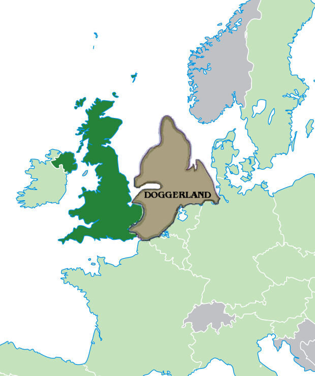
Beneath the grey waters of the North Sea, between the coasts of England, the Netherlands, Germany and Denmark, sleeps a forgotten country. For tens of thousands of years, where trawlers now drag their nets and oil platforms raise their steel silhouettes, there stretched a vast continental plain, crossed by rivers, dotted with lakes and marshes, clothed in forests and meadows. Archaeologists have given it a name: Doggerland. This territory was no negligible margin of the continent; it was its northern heart, linking Britain to the rest of Europe by a land bridge where human communities lived, where herds of aurochs and deer grazed, where countless waterfowl nested. Then, within a few millennia, the sea swallowed it1.
The story of Doggerland is that of a lost world, but it is also, and perhaps above all, that of a lesson. For this drowning belongs to no distant mythology: it unfolded over the span of a few hundred human generations, before the eyes of MesolithicMesolithicThe period between the Palaeolithic and the Neolithic (c. 10,000–6,000 BC in Europe), still based on hunting and gathering.→ populations who had to retreat, adapt, and abandon camps that became shorelines, then seabed. To reconstruct this geographical drama is to summon geology, palynology, radiocarbon datingRadiocarbon (carbon-14)A dating method based on the decay of carbon-14, usable back to about 50,000 years.→, sediment genetics and an archaeology of a peculiar kind, practised tens of metres below the surface. It is also, at a time when the contemporary rise of the oceans threatens the world's coastlines, to face a precedent: that of an inhabited land that the sea reclaimed.
What was Doggerland?
The name Doggerland was coined in the 1990s by the archaeologist Bryony Coles, in homage to the Dogger Bank, that vast shoal of the North Sea whose own name derives from the doggers, old Dutch fishing boats. But the territory so named existed long before any fishermen: it is the emerged plain that, during the cold phases of the PleistocenePleistoceneThe geological epoch of the great ice ages (c. 2.6 Ma–11,700 BP), spanning most of human prehistoryPrehistoryThe span of human history before the invention of writing, from the Palaeolithic to the Metal Ages, known mainly through material remains.→.→ and the early HoloceneHoloceneThe current geological epoch, begun about 11,700 years ago at the end of the last ice age; the setting of all post-glacial history.→, joined the British Isles to the European continent1.
Its geography varied with the glacial cycles. During the last glacial maximumLast Glacial MaximumThe peak of the last glaciation (c. 26,000 to 19,000 years ago), with ice sheets at their greatest extent; it pushed populations towards southern refuges.→, around 20,000 years ago, enormous volumes of water were locked in the continental ice sheets; global sea level then stood more than a hundred metres below today's. The southern North Sea was simply dry land. Doggerland then reached its greatest extent: an immense country welding continental Europe to Britain and stretching far to the north. With post-glacial warming, the melting ice released colossal quantities of water, and the sea began its slow reconquest. By around 10,000 BC, on the threshold of the Mesolithic, Doggerland nonetheless remained a vast and hospitable land, its area measured in tens of thousands of square kilometres1.
Far from the image of a desert swept by icy winds, early-Holocene Doggerland was a mosaic of richly varied environments. Cores and sediment analyses have restored its face: broad river valleys, including those of a then-extended Thames and Rhine, converged northward across the plain; vast wetlands, lagoons, estuaries and salt marshes fringed the shifting coasts; forests of birch and pine, then of oak, hazel, elm and lime, established themselves as the climateClimateThe long-term average atmospheric conditions of a region; its variations (glaciations, aridifications) shaped migrations, agriculture and the collapse of prehistoric societies.→ softened1. It was a lowland environment, fertile and game-rich, probably one of the most favourable in all of Europe at that time for the life of hunter-gatherersHunter-gatherersA way of life based on hunting, fishing and gathering wild resources, without farming or herding; it dominated almost the whole of human history.→.
The fauna of this plain matched it. Trawlers and dredgers have brought up from the floor of the North Sea a considerable quantity of bones that draw the inventory of a vanished ecosystem. Among them are remains of woolly mammoths and woolly rhinoceroses from the cold phases of the Pleistocene, but also, for the more temperate periods, aurochs, red deer, roe deer, elk, wild boar, wild horses, brown bears, beavers, and countless aquatic and migratory birds. The brackish and fresh waters teemed with fish; the coasts offered shellfish and seals. For mobile human communities, this was a land of abundance, where the diversity of resources allowed the effort of subsistence to be spread across the whole year2.
These dredged bones are not a uniform assemblage. Some belong to glacial fauna that roamed the dry North Sea basin during the cold stages, when mammoth, woolly rhinoceros and reindeer crossed a periglacial steppeSteppeA vast semi-arid, treeless grassland of Eurasia, suited to nomadic herding and the horse; a corridor for the movement of peoples and technologies in later prehistory.→; others belong to the temperate woodland fauna of the warming early Holocene. Read together, the trawled remains compress tens of thousands of years of environmental change into a single jumble on the deck of a fishing boat. Sorting and dating them, distinguishing a Pleistocene mammoth tusk from a Holocene red-deer antler, is itself a delicate scientific task, and one that has gradually turned the North Sea fishing fleet into an unwitting partner of palaeontology and prehistory.
The flora, reconstructed from pollen grains preserved in the sediments, tells the same story of gradual warming. The first tundra and grassy steppes of the end of the last glaciation gave way to pioneer forests of birch and pine, then, as temperature and humidity rose, to mixed deciduous woodland. Hazel in particular underwent a remarkable expansion in the early Holocene: its nuts, energy-rich and easy to store, were a first-rate resource for human populations. The wetlands offered reeds, reedmace, edible roots and tubers. This vegetation was no fixed backdrop: it shifted, transformed, followed the climate and, before long, retreated before the sea1.
The life of Mesolithic hunter-gatherers
Who lived on Doggerland? Groups of Mesolithic hunter-gatherers, that long period which, in north-western Europe, stretches roughly from the end of the last glaciation, around 9600 BC, to the arrival of farming several millennia later. The Mesolithic is no mere waiting interval between the PalaeolithicPalaeolithicThe oldest and longest period of prehistory (c. 3.3 Ma–12,000 BC), defined by chipped stone tools and a hunter-gatherer way of life.→ and the NeolithicNeolithicThe "New Stone Age": a period marked by farming, herding, settlement and pottery, from around 10,000 BC.→: it is an age of innovations of its own, of fine-grained adaptation to post-glacial environments in full recomposition, and of a way of life of great ecological sophistication1.
The inhabitants of Doggerland were not yet engaged in the sedentismSedentismThe shift from a nomadic life to lasting settlement in one place, a precondition for the rise of villages.→ that would characterise farming societies. They moved with the seasons, following herds, shoals of fish, the passage of migratory birds and the ripening of plant resources. But this mobility was no disordered wandering: it obeyed an intimate knowledge of the territory, established cycles, points of gathering and dispersal. Camps, often set near water, on a lakeshore, at the confluence of two rivers, on an estuary bank, were bases from which expeditions of hunting, fishing and gathering radiated out2.
Their technical equipment was remarkably suited to this world of lowlands and waters. The chipped stone is characterised by microliths, those small geometric bladelets mounted on shafts and hafts to arm arrows and harpoons. Wood, antler and bone supplied barbed points, fish-hooks, handles, paddles and even watercraft: the European Mesolithic is known for dugout canoes hollowed from tree-trunks and wooden paddles, evidence of a mastery of river and coastal navigation indispensable in a country as watery as Doggerland2.
Hunting targeted large and medium game, deer, boar, aurochs, elk, but fishing and the gathering of aquatic resources held an equally decisive place. The rivers and lagoons of Doggerland abounded in fish, and Mesolithic techniques for catching them were varied: woven traps, fish weirs, harpoons, lines. The gathering of hazelnuts, berries, roots and wetland plants rounded out a diverse and, all in all, robust diet. Far from the cliché of precarious survival, archaeology paints a portrait of well-nourished communities, able to exploit a great variety of environments with intelligence1.
The place of water in this existence cannot be overstated. Doggerland was a country of rivers, lakes, lagoons and estuaries; to move through it was often to travel by boat. The dugout canoes and paddles recovered elsewhere in northern Europe hint at a network of aquatic circulation linking camps, fishing grounds and hunting territories. This intimacy with the liquid element gave Mesolithic communities a particular reading of their land, structured less by overland routes than by watercourses and bodies of water. When the sea began to invade these lowlands, it therefore did not destroy a world foreign to water, but gradually turned familiar fresh waters into a hostile marine domain, salting the springs, drowning the marshes, erasing the landmarks1.
Of this social, spiritual and symbolic life we have only fragments, for the sea has covered everything. But comparisons with Mesolithic sites that remained on land, around the rim of former Doggerland, allow some reconstructions. Burials known elsewhere in northern Europe show elaborate funerary practices, sometimes cemeteries, bodies adorned with ornaments of pierced teeth and shells. Mesolithic portable artPortable artTransportable art objects (figurines, engravings on bone or ivory), such as the Palaeolithic Venuses.→, made of engravings on bone and antler, of geometric motifs and animal figures, suggests a universe of beliefs in which Doggerland must have had its share. Shorelines, confluences and springs, places of passage and resource, were probably charged with a meaning that largely escapes us2.
How many were they? Any estimate remains fragile, but the population densities typical of hunter-gatherers in rich environments, applied to the area of Doggerland, suggest that thousands, perhaps tens of thousands of people lived, at one moment or another, on this plain. It was no no-man's-land, but a peopled territory, a demographic heart of Mesolithic north-western Europe, whose drowning represents one of the largest losses of inhabited land in recent prehistory1.
The evidence: trawls, the Leman and Ower harpoonHarpoonA hunting and fishing weapon of reindeer antler or bone, fitted with barbs; an emblematic Magdalenian object whose forms help date archaeological layers.→, pollen and sedimentary DNADNAThe molecule carrying genetic information, used to reconstruct kinship between species.→
How do we know all this about a country buried beneath tens of metres of water? The discovery of Doggerland is inseparable from the history of industrial fishing in the North Sea. For more than a century, trawlers raking the bottom have brought up in their nets, mixed with the fish, fossil bones, mammoth tusks, antlers and, sometimes, objects shaped by human hands. These "trawl finds" first intrigued, then nourished a discipline in its own right1.
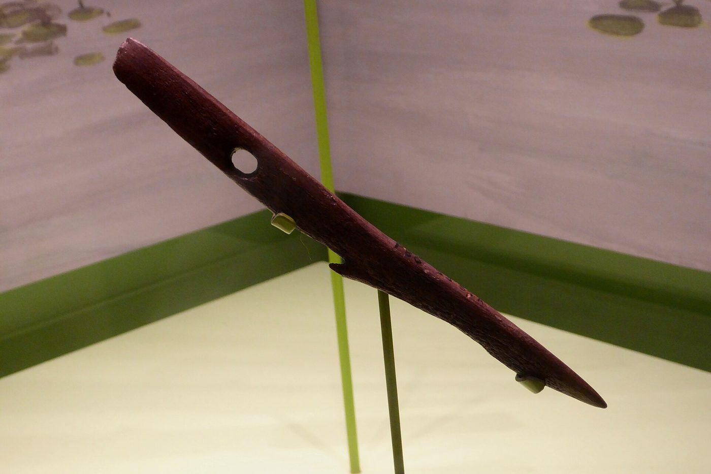
The emblematic piece of this involuntary underwater archaeology is the Leman and Ower harpoon. In 1931, the trawler Colinda, working over sandy banks between the Leman and Ower shoals off the east coast of England, hauled up in its nets a block of compact peatPeatA waterlogged organic soil formed by accumulated plants; it seals and remarkably preserves wood and ancient remains.→. Breaking it open, the crew found inside a finely worked barbed antler point, some twenty centimetres long. The object, dated to the Mesolithic, proved beyond doubt that the floor of the North Sea had once been dry land, covered with peat bogs, and roamed by hunters1. This harpoon, kept ever since as a founding relic, remains one of the most powerful symbols of Doggerland.
The peat itself is a precious archive. The blocks brought up by trawls, nicknamed moorlog by the fishermen, are in fact fragments of ancient organic soils, formed in drowned marshes and forests. Their analysis revealed very early on the remains of terrestrial plants, of trunks, of roots in place, so many proofs that these seabeds had been vegetated landscapes. As early as the start of the twentieth century, the geologist Clement Reid had sensed the existence of this "submerged forest" and glimpsed the scale of the lost continent1.
These organic materials nonetheless pose a problem of location: hauled up by a trawl or a dredge, they have been torn from their original context and dragged along the bottom before reaching the deck. We know they come from Doggerland, but rarely from which precise point. This is one of the great difficulties of this archaeology: to hold authentic objects and samples, but stripped of their stratigraphyStratigraphyThe study of the superimposed layers (strata) of an archaeological site; each layer corresponds to a phase of occupation and yields a relative chronology.→. Recent programmes strive precisely to correct this defect by going to retrieve samples from known and mapped locations, so as to place each clue within a reconstructed landscape rather than in a void2.
Palynology, the study of pollen grains and spores, transformed these intuitions into quantitative science. Pollen, microscopic and extraordinarily resistant, is preserved by the million in organic sediments. By identifying and counting it in cores taken from the floor of the North Sea, researchers reconstructed, layer after layer, the succession of vegetation and therefore of climates: glacial tundra, then birch and pine, then deciduous forest. Coupled with radiocarbon dating, which assigns an absolute age to each organic level, palynology has made it possible to date the evolution of Doggerland's landscapes and to follow, step by step, the advance of the sea1.
The convergence of these methods is what gives modern Doggerland research its strength. A single line of evidence, a trawled harpoon, a pollen spectrum, a strand of sedimentary DNA, a seismic profile, can only ever say so much. But cross-referenced, they begin to corroborate one another: the seismic reveals where a lake once lay, the core taken there yields peat, the peat carries pollen of lakeside trees and DNA of the animals that drank from it, and the radiocarbon date fixes the whole in time. Out of this triangulation emerges a picture far more robust than any single discipline could provide, and it is this integration, as much as any one find, that has resurrected the lost continent.
The most recent revolution has come from molecular biology. The seabed sediments in fact preserve ancient DNAAncient DNAGenetic material preserved in old remains, often degraded, sequenced with cutting-edge techniques.→: not only that of the organisms whose visible remains are found, but also environmental DNAEnvironmental DNADNA shed by organisms into their surroundings (soil, sediment, water, rock wall) and recoverable without any identifiable bodily remains.→, released by plants and animals into their surroundings and trapped in the mud. By extracting and sequencingSequencingReading the order of the bases (A, T, G, C) of a DNA molecule; high-throughput sequencing reads millions of fragments in parallel.→ this sedimentary DNA, researchers can detect the presence of species that left no macroscopic fossil: trees, herbs, mammals, sometimes traces of human activity. This approach, still in full development, opens the possibility of mapping Doggerland's biodiversity with unprecedented precision, from simple cores of mud2.
3D mapping: the Europe's Lost Frontiers project
To reconstruct an entirely drowned landscape requires tools able to "see" beneath the water and beneath the sediments. This is where data acquired, often for other purposes, by industry comes in. The oil and gas exploration of the North Sea has generated, over decades, gigantic volumes of seismic reflection data: by sending acoustic waves into the subsurface and recording their echoes, these surveys map the buried geological layers. Diverted from their industrial use, this three-dimensional seismic data has allowed researchers to reconstruct, over thousands of square kilometres, the buried relief of Doggerland: its river valleys, its lakes, its estuaries, its successive shorelines1.
The first major mapping work, carried out in the early 2000s under the name North Sea Palaeolandscapes Project, brought a true atlas of the lost continent out of the darkness of the depths. One can make out a great river network, sometimes dubbed the "northern Thames valley", broad plains, domes and depressions inherited from the retreat of the ice. This mapping transformed Doggerland from an abstract notion into a concrete landscape, whose contours could be followed on detailed maps1.
The Europe's Lost Frontiers project, deployed in the 2010s, pushed the ambition further still. Combining seismic mapping, targeted coring, dating, palynology and analysis of sedimentary DNA, this research programme aimed to reconstruct not only the topography of Doggerland but also its living ecosystems and the history of their transformation. The cores taken from palaeovalleys and palaeolakes precisely located by seismics provide sedimentary sequences that can be dated and analysed in detail. The goal is to move from a map of the relief to a genuine dynamic reconstruction: where the forests, marshes and shores lay, how they evolved, when and how the sea gained ground2.
This approach illustrates a profound shift in the archaeology of submerged landscapes. Where one once depended on the chance of trawls, there is now a strategy: model the buried relief, spot within it the places most likely to have been frequented by humans, confluences, lakeshores, terraces, then take targeted samples there. Doggerland thus becomes a methodological laboratory for the exploration of all the continental plains drowned by the post-glacial rise of the seas, from the Channel to the Baltic2.
The slow drowning: post-glacial sea-level rise
The disappearance of Doggerland was, in the main, a slow and inexorable process rather than a sudden cataclysm. Its engine is deglaciation. At the end of the Pleistocene, climatic warming melted the immense ice sheets that covered North America and northern Europe. These masses of water, returned to the oceans, raised global sea level by more than a hundred metres between the last glacial maximum and the middle of the Holocene. The rise was not steady: it had phases of abrupt acceleration, linked to major glacial outbursts, and phases of slowdown1.
Quantifying this rise is one of the achievements of Holocene research. Curves built from dated shorelines, submerged peats and coral and microfossil records show a sea climbing rapidly in the early Holocene, at times by more than a metre per century, before slowing as the great ice sheets dwindled. Applied to a low-gradient plain like Doggerland, even a modest vertical rise translates into a vast horizontal retreat of the coast: on nearly flat ground, the waterline can advance many kilometres for each metre the sea climbs. This geometric amplification explains why so large a land could be lost so completely in so short a span of geological time.
To this global phenomenon is added an essential regional component: isostatic rebound. Under the weight of the ice, the Earth's crust had sunk; relieved of its load, it rises slowly, like a raft eased of its cargo. But this uplift is not uniform. Where the ice was thickest, the land is still rising today; on the periphery, by contrast, a forebulge that had formed is subsiding. The southern North Sea, lying on this subsiding margin, sees its floor sink relatively, which has aggravated and accelerated the drowning of Doggerland beyond the effect of eustatic sea-level rise alone1.
The conjunction of these factors redrew the map of north-western Europe at a pace perceptible on a human scale. Valley after valley, estuaries cut inland, coastal marshes advanced, shorelines retreated by several kilometres in a few generations. Mesolithic communities had to reckon with this shifting world: a camp set on an estuary bank could, within a lifetime or two, find itself with its feet in salt water, then have to be abandoned. The hunting territory shrank, routes changed, resources moved1.
By around 7000 to 6000 BC, Doggerland had already shrunk considerably. The continuous land bridge linking Britain to the continent was breaking up into peninsulas, islands and sea-arms. The great central plain was turning into an archipelago of lowlands surrounded by ever more invasive waters. The definitive separation of Britain from the continent, the birth of the British island as we know it, is the outcome of this long process, whose last phase may have been precipitated by an event of sudden violence3.
The Storegga tsunami (around 6200 BC)
If the drowning of Doggerland was first a matter of centuries and millennia, it also had a brutal episode, whose geological memory is written in the sediments on both sides of the North Sea. Around 6200 BC, off the coast of Norway, a gigantic portion of the continental slope collapsed into the depths. This Storegga Slide, from the Norwegian "the great edge", ranks among the largest submarine landslides known from the Holocene: hundreds of cubic kilometres of sediment set in motion along a scar several hundred kilometres long3.
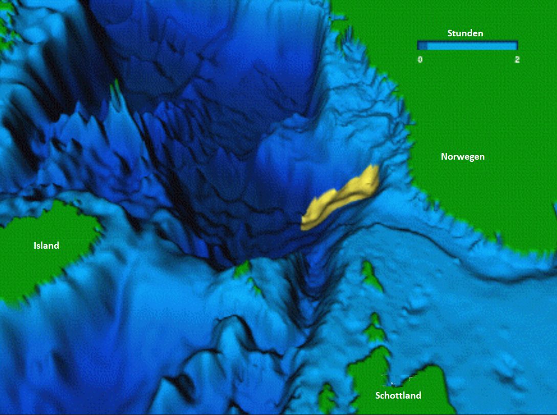
So massive a displacement of matter on the ocean floor moved an enormous quantity of water and generated a tsunami of great magnitude. The waves propagated across the North Atlantic and the North Sea, striking the coasts of Scotland, the Shetland Islands, Norway and, of course, the surviving shores of Doggerland. The deposits of this tsunami have been identified at numerous points: characteristic layers of marine sand, intercalated within sequences of peat or lake sediment lying well above the sea level of the time, attest to the passage of a sheet of water from the sea. At certain coastal sites in Scotland, these deposits reach considerable altitudes, a sign that the waves surged far up the land3.
For the Mesolithic communities still occupying the shores and islands of a drowning Doggerland, the impact must have been dramatic. Models of the Storegga tsunami suggest that the lowlands, already weakened by sea-level rise, were submerged by waves several metres high, sweeping away camps, resources and populations established on the coasts. Some researchers have proposed that this event may have dealt a decisive blow to the last emerged lands of central Doggerland and precipitated their definitive disappearance, turning a slow geographical agony into a catastrophe feltFeltA non-woven fabric made by pressing and matting wool fibres; steppe nomads used it for rugs, saddles and appliqués, remarkably preserved in the frozen Pazyryk tombs.→ in a single day3.
A note of caution is needed, however. Scientific debate remains open on the exact part played by the Storegga tsunami in the final drowning of Doggerland. For some, the event merely accelerated a process already almost complete, certain lands perhaps having been re-flooded then partly re-emerged before their definitive sinking. For others, Storegga's role in the rupture of the last land bridge was decisive. Recent work, integrating numerical modelling of the waves and mapping of the deposits, seeks precisely to quantify the scale of the flooding over residual Doggerland and to date the sequence of events finely3. Whatever the case, Storegga remains one of the most powerful reminders that coastlines are transformed not only by the slow rise of the waters, but also by sudden paroxysms.
The Dogger Bank, last island
As the sea engulfed the plain, the high points of Doggerland resisted longer. The most notable of them is the Dogger Bank, that vast shoal which today lies only a few tens of metres below the surface, in the centre of the North Sea. For a time, while the surrounding lowlands were already drowned, the Dogger Bank must have formed a large island, the last emerged remnant of the lost continent, separated from the British and continental coasts by sea-arms1.
The chronology of this drowning is no abstraction: it is measured, site after site, thanks to dated sedimentary sequences. Each layer of peat sealed by a marine deposit marks the moment when, at a given point, salt water finally won out. By multiplying these anchor points, researchers reconstruct an animated map of the drowning, showing the advance of the sea sector by sector, decade by decade. This approach reveals a landscape in perpetual recomposition, where still-dry zones, salinising marshes and newly opened sea-arms coexisted. Doggerland did not vanish in one block: it dissolved in fragments, like an endlessly receding coastline1.
This "island of Dogger" may have survived a few centuries, perhaps until around 6000 to 5000 BC, before it too disappeared beneath the waves. Whether human communities lived there to the end is unknown, but the idea of a final land, an island refuge in the midst of an expanding sea, exerts a powerful fascination. The Dogger Bank is, in a way, the last page of Doggerland: the point where the geography of a continent shrank to a sandbank, then to an invisible shoal1.
Today this shoal retains considerable importance, but of an entirely different order. Rich in marine life, the Dogger Bank is one of the historic fishing grounds of the North Sea and is subject to ecological protection measures. It also hosts immense offshore wind-farm projects, among the largest in the world. By an irony of history, the foundation works for these turbines, like dredging and cable-laying operations, disturb the sediments where the memory of Doggerland sleeps, and impose, in return, preventive underwater archaeological studies. The ancient land of the hunter-gatherers thus meets, on the floor of the North Sea, the infrastructure of the energy transition2.
What Doggerland teaches us about today's sea-level rise
The story of Doggerland is no mere palaeogeographical curiosity: it resonates strongly with contemporary concerns about climate change and rising sea levels. A few thousand years ago, a vast inhabited land was engulfed by the rise of the waters following a global climatic warming. The parallel is tempting, and it is partly justified, provided one also measures its limits2.
First lesson: sea-level rise can radically transform a geography in just a few centuries. Doggerland shows that a territory the size of a country can pass from densely living dry land to seabed within a handful of millennia, sometimes with spectacular accelerations. On the scale of human societies, which measure time in generations, such a transformation is anything but negligible: it entails population displacements, losses of territory, upheavals of ways of life2.
The human dimension of that transformation deserves emphasis. Behind the maps and the sediment curves lie communities that lost, generation after generation, the territories of their ancestors: hunting grounds, fishing places, perhaps burialBurialThe intentional deposition of a body, sometimes with offerings; a marker of symbolic behaviour.→ sites and places of meaning, swallowed by an advancing shore. Whether this loss was experienced as a slow erosion of the familiar world or, after Storegga, as an abrupt catastrophe, it is a reminder that environmental change is never only a matter of physical geography. It is always also a matter of memory, of identity and of the painful work of moving on.
Second lesson: low-lying coastlines are the most vulnerable. Doggerland was a lowland plain; this is precisely what made it easy prey for the sea. Yet today's densely populated low-lying coasts, deltas, coastal plains, polders, show the same exposure. The precedent of Doggerland recalls that no hundred-metre rise is needed to upend these spaces: a few metres, or even less, suffice to redraw coasts and render once-safe lands uninhabitable2.
Third lesson, supplied by Storegga: the gradual rise of the waters can be compounded by brutal events. Landslides, major storms, surge waves: the combination of a higher sea level and extreme hazards amplifies coastal risks. A higher sea means tsunamis and storms that penetrate further and higher inland. Doggerland teaches us not to think of sea-level rise as a purely linear and predictable process3.
One must, however, beware of overly simple analogies. The drowning of Doggerland was essentially natural in origin, linked to the end of a glaciation, and unfolded over millennia; today's warming is largely anthropogenic in origin and is occurring at a speed unprecedented on the recent geological scale. Mesolithic societies, mobile and few, could retreat before the sea; contemporary societies, with their coastal cities, fixed infrastructure and billions of inhabitants, do not have the same latitude. Doggerland is therefore not a predictive model, but a powerful historical reminder: the sea has already reclaimed inhabited lands, and it can do so again2.
Underwater archaeology: methods and challenges
Studying a continent buried beneath the waters and the sediments is one of the most demanding challenges of contemporary archaeology. The obstacles are considerable: depth, the turbidity of the North Sea's waters, the sedimentary cover that seals the ancient landscapes, the gigantic extent of the surfaces to explore, the cost of campaigns at sea. Where the field archaeologist digs with a trowel, the archaeologist of submerged landscapes must work with ships, sonars, corers and divers2.
The first step is acoustic mapping. Seismic reflection, inherited from the oil industry, and scanning sonars make it possible to reconstruct the buried relief and to spot the sedimentary structures, palaeovalleys, palaeolakes, terraces, likely to have sheltered human occupations. This underwater remote sensing replaces direct observation, impossible on a large scale, and guides the whole research strategy by designating the priority targets1.
Next comes coring. Taking columns of sediment from the identified palaeolandscapes gives access to the organic archives: pollen, plant macroremains, insect remains, sedimentary DNA. Each core is a vertical window onto time, whose successive layers tellTellAn artificial mound formed by the accumulation of successive layers of settlement remains at the same spot, typical of the Near East. Each destruction-rebuilding event adds a stratum.→ the history of the environment. Radiocarbon dating provides the chronology, while biological and geochemical analyses restore the environments. It is through this patient accumulation of individual cores that the living face of Doggerland is reconstructed, point by point2.
Underwater excavation proper, where Palaeolithic or Mesolithic sites outcrop on the bottom or are accessible at shallow depth, remains exceptional and difficult. It requires diver-archaeologists, recording protocols adapted to the marine environment, heavy logistics. The rare Mesolithic sites excavated underwater, notably along the Danish coasts and in nearby coastal contexts, have yielded spectacular results, wood, fibres, organic objects exceptionally preserved by the absence of oxygen, that let us imagine the richness of what the floor of Doggerland still holds2.
Time, too, is a challenge. The very processes that drowned Doggerland continue to act on its remains: currents scour exposed surfaces, modern fishing gear ploughs the seabed, and the slow chemistry of the marine environment degrades what oxygen-poor peat had protected for millennia. Each season that passes without study is a season in which evidence is lost. This lends a quiet urgency to the work, and helps explain why archaeologists increasingly seek to embed their research within the great offshore engineering projects, capturing what can be recorded before turbine foundations and cable trenches cut through the buried landscape for good.
The challenges are not only technical. The conservation of the submerged heritage, its protection against trawling, dredging, aggregate extraction and major offshore works, raises new legal and ethical questions. Archaeological impact studies preceding wind farms, cables and pipelines are becoming a major tool of knowledge as much as of preservation. Doggerland, long elusive, is becoming a genuine territory of research, equipped with its methods, its programmes and its heritage stakes2.
Conclusion
Doggerland is a paradox: a country whose face we have never seen, and which we nonetheless reconstruct with growing precision. A fertile, game-rich plain in the early Holocene, peopled by skilful Mesolithic hunter-gatherers well adapted to their world of waters and forests, it was slowly reclaimed by the sea over the course of the deglaciation, before the Storegga tsunami struck its last shores around 6200 BC. The Dogger Bank, the final island, eventually sank in its turn, sealing the birth of an insular Britain and the erasure of a heart of north-western Europe1.
There is, finally, something fitting in the fact that Doggerland is being recovered just as the world begins to grapple anew with rising seas. The discipline that maps the drowned plain and the science that models future coastlines draw on the same understanding of how ice, ocean and land interact. In studying the death of one inhabited country, we sharpen the tools we will need to defend others. The lost continent is no longer merely a romantic image of an Atlantis beneath the North Sea; it has become a working archive of how landscapes are lost, and, perhaps, a quiet argument for taking the next rise of the waters seriously2.
From this history, underwater archaeology and the environmental sciences today draw an ever more detailed account, thanks to trawl finds, the Leman and Ower harpoon, pollen, sedimentary DNA and the great mapping campaigns such as Europe's Lost Frontiers. But Doggerland is not only an object of knowledge: it is also a warning from the past. It reminds us that the sea has already engulfed inhabited lands, that low-lying coastlines are fragile, and that the rise of the waters, slow or sudden, is part of the long history of humanity. At a time when the oceans are beginning to climb once more, the lost continent of the North Sea watches us from its depths, and speaks to us of a possible future2.
On a passé toute une soirée à parler de ça en famille. Merci pour ce moment !
Le Doggerland est un sujet fascinant pour un documentaire car il permet de parler à la fois de préhistoire, de géologie, de montée des eaux et de manière inévitable, des enjeux climatiques contemporains. La technique de reconstitution virtuelle du paysage submergé, à partir des données bathymétriques et des modèles environnementaux, permet des séquences visuelles très évocatrices.
Le Doggerland est l'une des histoires les plus mélancoliques de la préhistoire : un pays entier englouti sous la mer du Nord depuis 8 000 ans. Des familles de chasseurs-cueilleurs vivaient là, sur des plaines et des collines qui sont aujourd'hui à 40 mètres sous l'eau. Les filets des pêcheurs de la mer du Nord remontent parfois des os d'animaux, voire des outils humains de cette époque disparue.