In early March 2025, a story from north-eastern Romania made the rounds of the archaeology world: beneath the cover of a dense forest, a few kilometres from the small town of Târgu Neamț in Neamț County, researchers had spotted the remains of fortifications some 5,000 years old. Not by scratching at the soil, nor by following the clues of a classic ground survey, but by flying over the canopy with drones fitted with a laser sensor. In a few hours of flight, the device had stripped the forest of its trees, on screen, at least, to reveal what centuries of dead leaves and roots had carefully hidden: long ditches, earthen banks, a perched defensive enclosure that once commanded the valley [[#s1]].
The case is enticing far beyond the circle of specialists. It brings together two stories that echo each other across five thousand years. On one side, late NeolithicNeolithicThe "New Stone Age": a period marked by farming, herding, settlement and pottery, from around 10,000 BC.→ and Eneolithic communities that, at the hinge between the age of stone and the age of metal, saw fit to dig ditches and raise earthen banks to protect themselves, a gesture heavy with meaning in a world we tend to imagine peaceful. On the other, a cutting-edge technology, airborne LiDARLiDARLaser-based remote sensing (from "Light Detection And Ranging"): a sensor fires light pulses and measures the echo's return time to map a surface in three dimensions. Mounted on a plane or a drone, it slips through gaps in the canopy and reconstructs the bare-earth relief, revealing structures invisible beneath vegetation.→, which over the past few years has transformed the way we search for, and find, the traces of the past beneath the forests of the entire world. Between the two stands a patient Romanian team, hours of computation, and the stubborn conviction that, under the foliage of the Carpathians, far more sites remain to be found than anyone ever suspected [[#s2]].
This article sets out to take the time to understand the discovery: what LiDAR sees, and how; what the relief of Neamț tells us; who built these fortresses; why, five millennia ago, farmers feltFeltA non-woven fabric made by pressing and matting wool fibres; steppe nomads used it for rugs, saddles and appliqués, remarkably preserved in the frozen Pazyryk tombs.→ the need to entrench themselves; and what all this changes, concretely, for a discipline still largely blind to what hides beneath the trees. We shall also see why caution remains in order: spotting a structure is not dating it, and the image of a ditch on a screen does not replace the trowel of an excavator.
LiDAR, a tool that sees beneath the trees
To grasp the scale of the Târgu Neamț discovery, one must first understand the instrument that made it possible. LiDARLiDARLaser-based remote sensing (from "Light Detection And Ranging"): a sensor fires light pulses and measures the echo's return time to map a surface in three dimensions. Mounted on a plane or a drone, it slips through gaps in the canopy and reconstructs the bare-earth relief, revealing structures invisible beneath vegetation.→, short for "Light Detection And Ranging", is an active remote-sensing technique. Rather than passively recording the sunlight reflected by a landscape, as a camera does, a LiDAR sensor fires its own light pulses, tens or even hundreds of thousands per second, and measures very precisely the time each echo takes to return. Since the speed of light is known, this delay translates into distance. By repeating the operation millions of times during the flight, and cross-referencing these measurements with the device's exact position supplied by GPS and an inertial unit, one obtains a gigantic three-dimensional scatter of points: the famous "point cloud".
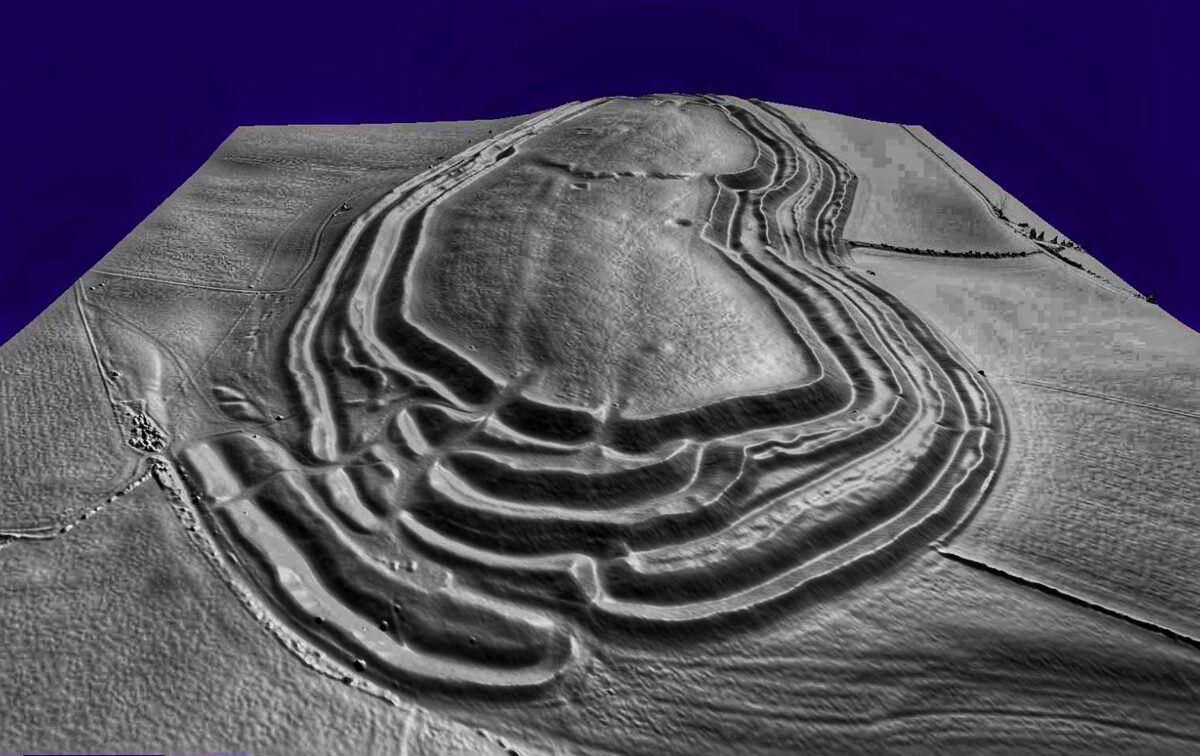
The power of the method, and what makes it a revolutionary tool for forest archaeology, comes down to one crucial detail: the laser light does not merely bounce off the treetops. Some of the pulses slip between the leaves, branches and twigs, pass through gaps in the canopy, and finally strike the bare ground before travelling back to the sensor. For a single line of sight, the device therefore records several successive echoes: the first on the canopy, others on the intermediate vegetation, and the last, the most precious, on the earth itself. By computationally sorting these returns and keeping only those that correspond to the ground, one "erases" the forest digitally. The result is a digital terrain model, or DTM, which represents the relief as it would be if all the vegetation had been razed [[#s3]].
On this stripped model, archaeological structures finally appear. A filled-in ditch is, at the surface, no more than a barely perceptible depression that moss and leaves conceal; on the DTM, it is a clear groove running across the landscape. A bank worn down by a thousand years of erosion forms a mere undulation invisible at eye level; on the shaded-relief image, it traces an obvious crest. Earthworks, sunken lanes, enclosures, burialBurialThe intentional deposition of a body, sometimes with offerings; a marker of symbolic behaviour.→ mounds, ancient fields: anything that even slightly alters the shape of the ground leaves a signature that the laser can read, where the human eye, overwhelmed by the mass of trees, sees only an undifferentiated forest.
It is worth stressing what radically sets LiDAR apart from ordinary aerial photography. A photograph, even taken from a plane or a satellite, records only what daylight illuminates: the treetops, and nothing else, where the forest is dense. LiDAR, by contrast, is active and multi-echo. Each pulse can return several signals, and it is by exploiting the last returns, those that travelled furthest, and so struck the ground, that software reconstructs the terrain. This ability to classify points according to their origin (ground, low vegetation, canopy) is the real technical feat, and it rests as much on the hardware as on increasingly powerful filtering algorithms.
The final rendering, moreover, no longer has much to do with a raw image. To bring out the microrelief, specialists apply to the digital terrain model a whole battery of treatments: simulated shading from several lighting angles, slope maps, curvature analyses, the highlighting of hollows and bumps. A single ditch invisible on a vertical view can become striking under a grazing light coming from the right azimuth. To read a DTM is therefore also to know how to light it: a ditch oriented north-south will not show up under a simulated sun coming from the north, and the analyst must multiply the angles so as to miss nothing.
Airborne LiDAR is not a 2025 novelty. The technique has existed since the 1990s and achieved its first spectacular archaeological triumphs in the jungle, notably over the Maya cities of Central America, where it revealed entire networks of towns, roads and canals swallowed by tropical forest. What has changed recently, and what explains the acceleration of discoveries since around 2020, is the miniaturisation of sensors and their mounting on civilian drones. Where one once had to charter a plane, mobilise a substantial budget and overfly vast expanses, one can now launch a light drone over a precise parcel, at low altitude, at a cost and with a logistics that bear no comparison. Resolution improves, the price drops, and modest-sized teams gain access to a tool once reserved for major programmes [[#s2]].
The discovery near Târgu Neamț
Târgu Neamț is a small town in north-eastern Romania, nestled at the foot of the eastern foothills of the Carpathians, in that region of wooded hills and deep-cut valleys known as Romanian Moldavia. The land is ancient, and its soil keeps the memory of very long human occupations: it is here, in Neamț County and its neighbours, that one of the most brilliant cultures of prehistoric Europe flourished. It was in this setting of deep forests and heights commanding the rivers that the Romanian team concentrated its drone flights, searching for what the plant cover might conceal.
The result exceeded expectations. Beneath the trees, LiDAR brought to light not a single isolated site but a whole set of defensive structures: fortified sites established on high positions, which dominated the surrounding landscape and clearly controlled the routes and valleys. On the digital terrain models, the researchers recognised the classic elements of prehistoric defensive architecture: ditches, sometimes several hundred metres long, and the banks or earthen ramparts that accompanied them, the worn-down vestiges of what was once a coherent system of protection [[#s1]].
The proposed dating points to a broad but coherent bracket: about 5,000 years, which places these works at the transition between the end of the Neolithic and the Bronze Age, in the phase that specialists of south-eastern Europe call the EneolithicEneolithicThe "Stone-and-Copper Age": a transition between the Neolithic and the Bronze Age (c. 5000–3000 BC in south-eastern Europe), marked by the first copper objects, large farming settlements and, in places, the rise of fortified sites. Broadly synonymous with ChalcolithicChalcolithicThe "Copper Age": a transition between the Neolithic and the Bronze Age, marked by the first copper objects (Ötzi's era).→.→. Some of these sites might even belong fully to the Bronze Age that follows. What strikes one is the scale of the effort involved: digging and maintaining ditches several hundred metres long, raising earthen banks, choosing and fortifying commanding spurs represented, for farming communities, a considerable collective investment in time and labour.
One must measure what this change of gaze means for regional knowledge. Neamț County and its surroundings were already known to prehistorians as a major focus of ancient occupation; settlements, necropolises and surface stations had long been identified there in the open areas. But the wooded massifs, which cover a considerable part of the territory, remained an archaeological terra incognita. By turning the gaze beneath the trees, LiDAR does not merely complete the map: it reveals whole swathes of it left blank for want of being able to explore them. The discovery of fortified structures in these hitherto silent sectors rebalances our image of settlement and suggests that the wooded heights, far from being margins, may have played a strategic role of the first importance.
The discovery is no isolated stroke of luck. It is part of a wider LiDAR mapping campaign conducted in the region, whose leaders stress that it is only beginning to reveal its potential. Each newly overflown parcel seems to yield its share of hitherto unsuspected structures, to the point that the researchers reckon many fortified sites still lie hidden beneath the forest, simply waiting for a drone to pass over them. It is not so much that the existence of prehistoric settlements in the region was unknown: it is that, until now, there was no effective way of detecting them under such a dense forest cover [[#s2]].
What the relief reveals: ditches, banks and ten hectares
When one speaks of a prehistoric "fortress", one must set aside images of stone walls and crenellated towers. The fortifications of the late Neolithic and the Bronze Age in south-eastern Europe are not castles: they are earthwork systems, made of earth dug out and piled up, where ditch and bank form an inseparable couple. One digs a trench, the moat, the ditch, and throws the excavated earth inward or outward to form a bank, an earthen rampart that a now-vanished wooden palisade may have crowned. It is precisely this arrangement that LiDAR has brought back to light on the heights of Neamț.
The figures put forward give the measure of these works. Some ditches run for several hundred metres, hugging the topography to bar a spur or encircle a summit. The defensive footprint of one of the sites is said to reach about ten hectares, a considerable area, equivalent to a dozen football pitches, which suggests a protected space large enough to shelter a genuine community, its dwellings, its stores and perhaps its livestock. This is far from a simple occasional refuge: these are works conceived on the scale of an entire group, or even several [[#s3]].
The position is just as telling as the dimensions. The sites occupy high points that command the surrounding landscape. This choice is anything but trivial. An elevated position first offers an obvious defensive advantage: the attacker must climb a slope, in the open, under the gaze of the occupants, while the ditch and bank multiply the obstacles. It also provides visual control of the territory, valleys, paths, watercourses, and therefore the ability to monitor comings and goings, to anticipate a threat, to signal at a distance. Finally, to dominate the landscape is also to impose oneself upon it: a perched enclosure visible from afar is a message addressed to the neighbourhood as much as a means of protection.
Within the broader Eneolithic of south-eastern Europe, fortified or enclosed settlements are not unheard of: ditched enclosures and ramparted hilltops are known across the region, from the Balkans to the Pontic margins. What the Neamț survey adds is a fresh tranche of such sites in a zone where the dense forest had kept them out of reach, and where the very fact of their concentration on commanding heights begins to sketch a pattern. A scatter of fortified spurs along the eastern Carpathian foothills is not the same thing as a single isolated stronghold: it hints at a contested landscape, at routes worth watching and resources worth holding.
That said, read on a DTM, these works keep their share of mystery. The relief tells where the ditches are, their course, their length; it does not, on its own, tellTellAn artificial mound formed by the accumulation of successive layers of settlement remains at the same spot, typical of the Near East. Each destruction-rebuilding event adds a stratum.→ when they were dug, how long they served, or whether they were all contemporary. A single site may have been fortified, abandoned, reoccupied and refortified over centuries, superimposing layouts that only excavation will untangle. The laser image is an invitation card: it shows where to dig, it does not replace the digging.
The team and the method: drones, lasers and a field archaeologist
Behind this discovery lies a collaboration between Romanian institutions with complementary skills. The mapping was carried out by the specialised companies and laboratories Geocad Services and Geo Edu Laboratory, in partnership with the National Institute for Research and Development in Earth Physics, a body used to processing geophysical and geospatial data. To each its role: flying the drones, calibrating the sensors, acquiring the point cloud, then the long work of computer processing that turns millions of raw measurements into a usable terrain model [[#s2]].
The properly archaeological side of the project was supervised by Vasile Diaconu, an archaeologist attached to the Neamț County Museum Complex. It fell to this specialist, a fine connoisseur of regional prehistoryPrehistoryThe span of human history before the invention of writing, from the Palaeolithic to the Metal Ages, known mainly through material remains.→, to interpret the relief anomalies, to distinguish a defensive structure from a mere natural accident of the ground, and to set these discoveries within the framework of the cultures that succeeded one another in the region. This articulation is essential: a DTM, however precise, does not read itself. It takes a trained eye to recognise, amid the profusion of ground undulations, the forms that betray an ancient human intervention and those that owe nothing but to geology or recent forestry.
The method, in principle, chains together several stages. One begins by planning flights over the zones deemed promising, gridding the terrain to ensure complete coverage and a sufficient point density. The drone, flying at low altitude, sweeps the surface while its sensor fires its laser pulses. Then comes the processing phase: the point cloud is filtered to separate ground echoes from those of vegetation, the digital terrain model is generated, then shading and slope-analysis treatments are applied that bring out the microrelief. It is on these visualisations that the archaeologist hunts for ditches and banks.
One of the great merits of this approach lies in its non-destructive character. Where excavation, by definition, destroys what it studies, one never excavates the same layer twice, LiDAR touches nothing. It maps, measures and documents without lifting a single clod of earth. This makes it an ideal prospecting tool for spotting and ranking sites before any intervention, for deciding where to direct the effort, and for protecting a heritage whose very existence was unknown. In a forested region where ground survey is slow, difficult and often fruitless, it is a methodological revolution [[#s1]].
Who built these fortresses: the Cucuteni-Trypillia culture
To understand who might have raised these enclosures, one must trace back the thread of the societies that peopled north-eastern Romania five thousand years ago. The region lies at the heart of a vast cultural area that marked European prehistory: the Cucuteni-TrypilliaCucuteni-TrypilliaA vast Eneolithic culture of south-eastern Europe (c. 5000–3000 BC), spread across Romania, Moldova and Ukraine. Famous for its spiral-painted pottery, its figurines and its huge settlements of several thousand inhabitants, sometimes cyclically burned and rebuilt.→ culture, named after the Romanian village of Cucuteni, near Iași, where it was identified at the end of the nineteenth century, and after the Ukrainian site of Trypillia that gave it its second name. This culture spread, between roughly 5000 and 3000 BC, over an immense territory covering eastern Romania, the Republic of Moldova and a large part of Ukraine.
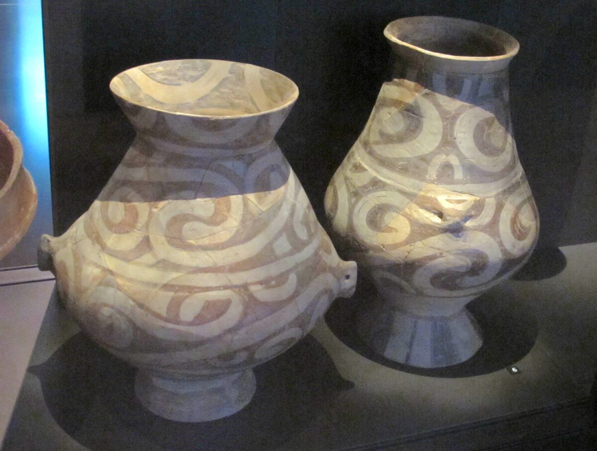
Cucuteni-Trypillia is first famous for its pottery. The potters of this culture produced vessels of remarkable technical and aesthetic quality, with a fine paste, adorned with motifs painted in spirals, bands and meanders, in a range of red, black and white of striking elegance. This refined, abundant and highly standardised pottery testifies to an elaborate collective know-how and a shared aesthetic sense spanning hundreds of kilometres. Alongside the vessels, one finds a multitude of terracottaTerracottaClay shaped and then hardened by firing; the material of pottery, bricks and figurines, ubiquitous since the Neolithic.→ figurines, often female, whose interpretation, deities, ancestors, toys, ritual props, remains debated.
But the most astonishing feature of this culture is the scale of its settlement. In their most developed phase, the Cucuteni-Trypillia communities built some of the largest settlements of prehistoric Europe, true proto-cities that could spread over several hundred hectares and shelter, by some estimates, several thousand inhabitants. The houses, made of wood and wattle-and-daub, were arranged in concentric circles or regular plans, sometimes around central empty spaces. One phenomenon particularly intrigues researchers: regularly, at intervals of a few decades, these settlements appear to have been deliberately burned, then rebuilt, a cycle of destruction and rebirth whose meaning still escapes us, between practical necessity, ritual and social renewal.
The long span of the Cucuteni-Trypillia culture unfolds over several phases, from the first settlements around 5000 BC to its extinction around 3000. It is in its late stages, when the great settlements reach their maximum extent and then begin their decline, that signs of a world under tension concentrate. Contact with populations arriving from the Pontic steppes to the east, bearers of other, more mobile and more herding-oriented ways of life, alters the regional balance. Some researchers see in this one of the possible causes of the growing fortification of sites: faced with a changing and at times threatening neighbourhood, entrenching oneself becomes a rational response. The fortresses of Neamț may fit precisely into this moment of crisis and reorganisation.
It is in this context that the appearance of fortified structures around 3000 BC, in the late phase of Cucuteni-Trypillia and on the threshold of the Bronze Age, takes on its full meaning. Communities capable of building immense villages, producing standardised pottery and organising a territory on a large scale certainly had the collective organisational capacity needed to dig ditches and raise earthen ramparts. The fortresses of Neamț could thus be the work of these societies, or of those that immediately succeeded them, at a moment when something, in the balance of the Neolithic world, seems to have grown taut [[#s3]].
The Eneolithic and the transition to the Bronze Age
The period known as the EneolithicEneolithicThe "Stone-and-Copper Age": a transition between the Neolithic and the Bronze Age (c. 5000–3000 BC in south-eastern Europe), marked by the first copper objects, large farming settlements and, in places, the rise of fortified sites. Broadly synonymous with Chalcolithic.→, literally the "age of stone and copper", sometimes called the Chalcolithic, is one of the most decisive in European prehistory, and one of the least known to the general public. It occupies a pivotal position: neither quite the Neolithic of the first farmers, nor yet the Bronze Age of hierarchical societies, it is that long moment of transition when the continent's communities learn to work metal while remaining fundamentally peasant societies.
Copper is the great protagonist of this period. First cold-hammered like a slightly peculiar stone, it is gradually smelted, cast in moulds, alloyed. This nascent mastery of metallurgyMetallurgyThe techniques of extracting and working metals (copper, bronze, gold); its rise in the Eneolithic and Bronze Age transformed tools, weapons and social hierarchies.→ changes many things, not only because it provides new tools and new ornaments, but because it introduces into the social fabric rare, precious objects whose possession sets one apart. Metal becomes a marker of status, a good of exchange, a mobilisable wealth. With it emerge differences of fortune and rank that the earlier, more egalitarian Neolithic societies largely ignored.
The Eneolithic is also a period of movement and contact. Exchange networks extend and intensify: copper, but also salt, fine flintFlintA hard, brittle siliceous rock, knapped by prehistoric people to produce blades, points and sharp tools.→, certain shells and precious stones circulate over long distances. These flows connect distant communities, spread techniques and fashions, but also create tensions, covetousness and rivalries for control of resources and routes. In south-eastern Europe, this effervescence coincides with the apogee and then decline of great cultures such as Cucuteni-Trypillia, and with the arrival, from the eastern steppes, of populations with different traditions.
This shift was neither sudden nor uniform. Depending on the region, metallurgy spreads at different rates, and Eneolithic societies long retain much of their Neolithic heritage: farming, herding and village life remain the bedrock of existence. What changes is less the economic base than the social texture. The appearance of rare goods, the specialisation of certain tasks, the intensification of exchanges and, perhaps, the rise of tensions all combine to differentiate individuals and groups more sharply. It is in this soil that the more marked hierarchies of the Bronze Age germinate, and it is in this context that one must place the meaning-laden gesture of fortifying oneself.
It is in this climateClimateThe long-term average atmospheric conditions of a region; its variations (glaciations, aridifications) shaped migrations, agriculture and the collapse of prehistoric societies.→ of transformation that the Bronze Age takes root. The alloy of copper and tin, harder and more efficient than copper alone, will give its name to the following period and further accelerate the changes begun in the Eneolithic: the rise of elites, the intensification of very long-distance exchanges, the assertion of personal powers. The fortified sites of Neamț, dated around this hinge, are precious witnesses to this tipping point. Whether they belong to the end of the Eneolithic or the beginning of the Bronze AgeBronze AgeA protohistoric period following the Neolithic, defined by bronze metallurgy (a copper-tin alloy) and the rise of the first cities and states; in Egypt it corresponds to the age of the first pyramids.→, they belong to this changing world, where collective protection becomes a tangible concern [[#s2]].
Why fortify 5,000 years ago: war, territory, prestige
The question seems simple and yet remains one of the most debated in archaeology: why did farming communities, five thousand years ago, devote so much energy to fortifying themselves? Digging ditches several hundred metres long, raising earthen banks, choosing and developing high positions: all this represents thousands of hours of work subtracted from the fields, the herds and daily life. One does not consent to such an effort without a strong reason. Several hypotheses, not mutually exclusive, are put forward.
The first, the most obvious, is conflict. A fortification protects, that is its primary function and its very name says so. The presence of ditches and banks suggests that these communities feared attacks: cattle raids, raids targeting grain stores, conflicts for control of fertile lands or strategic points. The end of the Neolithic and the Eneolithic in Europe are marked, here and there, by signs of violence, weapons, traces of destruction, sometimes burials of victims, that remind us this world was not the peaceful idyll one has sometimes imagined. Demographic pressure, competition for coveted resources, the arrival of new groups: all factors liable to have inflamed tensions.
The second hypothesis is territorial. An enclosure is also a boundary, a way of marking and claiming a space. By settling on a height and surrounding it with ditches, a community asserts: this is ours, we hold it, we will defend it. The visual control offered by commanding positions takes on its full meaning here: to watch the valleys and paths is to watch one's territory, one's neighbours, one's resources. Fortification becomes an instrument of appropriation and regulation of space, in societies where land begins to matter as never before.
The third hypothesis, more subtle, has to do with prestige and symbol. To build a great enclosure on a summit visible from afar is not merely useful: it is impressive. It is a demonstration of a group's ability to mobilise labour, to organise itself, to impose its mark on the landscape. In a society where differences of rank are emerging, the collective work can serve as an assertion of identity and a support of power: it speaks of the group's cohesion, the legitimacy of those who led it, the place it intends to hold against others. Protection, boundary and prestige are not mutually exclusive, a single enclosure could fulfil, simultaneously, these three functions [[#s1]].
Finally, one must beware of projecting everything at once. Not all fortifications are equal, and not all answer the same needs. Some may have been occasional refuges, occupied only in case of danger; others, permanent residences; still others, centres with a ritual or political vocation as much as a defensive one. Only the detailed study of each site, its size, its internal layout, its finds, its duration of occupation, will settle the matter. LiDAR opens the door; it falls to excavation to furnish the room.
What this changes for forest archaeology
The Neamț discovery is not merely the addition of a few sites to a regional inventory: it illustrates a profound mutation of archaeology itself. For decades, forests constituted a blind spot of research. What lay in the open, in cultivated fields, could be detected by ground survey, by aerial photography or by observing the marks that buried remains imprint on crops. But under tree cover, these methods become largely inoperative: the canopy masks the ground from aircraft, dense vegetation hampers walking and seeing, and one could pass within a few metres of a five-thousand-year-old rampart without suspecting a thing.
Airborne LiDAR has broken this lock. By reconstructing the relief beneath the vegetation, it transforms the forest, once an obstacle, into a mere veil that a computer treatment draws aside. The consequences are dizzying. Entire regions, long deemed archaeologically "empty" because wooded, turn out in fact to have been densely occupied in the past. It is not that nothing was there: it is that one could not see it. The map of prehistoric settlement, in many forested regions of Europe and beyond, is being redrawn [[#s2]].
The Romanian case is part of a worldwide movement. Beneath the jungles of Central America, LiDAR has brought forth entire Maya cities, with their networks of roads, reservoirs and raised fields, revealing an unsuspected population density. In South-East Asia, it has redrawn the surroundings of Angkor. In Europe, it is today mapping camps, enclosures, burial mounds and ancient field systems beneath the forests of England, Germany or the Carpathians. Everywhere, the finding is the same: the forest was never a human desert, it was merely a veil. The fortifications of Neamț extend this planetary lesson to the scale of a region of Eastern Europe long kept away from the great spotlights.
This acceleration is all the more marked as costs have fallen. The shift from plane to drone has democratised access to the technique. A regional team, a county museum, a university laboratory can now run their own laser-survey campaigns, on budgets unrelated to those of the past. The Neamț discovery, the fruit of a collaboration between modest-sized Romanian bodies, is the perfect illustration: it is no longer the preserve of great international programmes. The technology has come within reach of those working on the ground.
There is, too, a quieter benefit to the method that is easy to overlook: it builds a permanent, shareable record. A point cloud and the terrain model derived from it can be archived, reprocessed with better algorithms years later, compared across successive surveys, and consulted by researchers who never set foot in the forest. A site that is mapped is, in a sense, secured against forgetting, and against certain forms of destruction, since one can monitor it from the air without disturbing it. In a region where illicit digging and uncontrolled forestry can erase a fragile earthwork in a season, this documentary value is far from trivial.
The campaign leaders say it bluntly: what has been found is probably only a fraction of what still sleeps beneath the trees. Each additional flight over the Moldavian Carpathians could reveal new fortified sites, new settlements, new structures. We move from an archaeology of the occasional, chance discovery to a systematic archaeology of the landscape, able to map vast territories and read in them the trace of vanished societies. It is a change of scale, and almost of nature [[#s3]].
Limits and caution: dating, excavating, verifying
The enthusiasm aroused by these discoveries must not make us forget the limits of the method and the caution the results demand. The first warning concerns dating. LiDAR detects shapes in the relief; it does not date them. When one speaks of fortifications "about 5,000 years old", this is an attribution based on the morphology of the structures, on their resemblance to already known and dated sites, and on the regional cultural context. It is a solid working hypothesis, but a hypothesis. Only excavations, with the sampling of material and radiocarbonRadiocarbon (carbon-14)A dating method based on the decay of carbon-14, usable back to about 50,000 years.→ dating, will be able to confirm the exact age of each work.
The second warning concerns the interpretation of the images themselves. Not all relief anomalies are archaeological. Nature produces ditches, banks and terraces; modern forestry, ancient agricultureAgricultureThe cultivation of plants and production of food by working the soil, which emerged in the Neolithic in the Near East and independently elsewhere; it radically transformed human societies.→, paths, quarries and drainage works leave marks in the soil that can imitate, on a DTM, prehistoric structures. Distinguishing the ancient human work from the natural accident or the recent development requires experience, cross-checking and, often, verification on the ground. The archaeologist's eye remains indispensable to avoid both false positives and omissions.
The third limit is that LiDAR, by construction, sees only the surface of the ground. It reveals what modifies the relief, but remains blind to what is entirely buried without leaving a surface trace: a sealed occupation layer, a flat burial, a deposit without a mound. A ditch filled and levelled until it disappears from the relief escapes the laser. The method is powerful, but partial: it belongs to a toolkit in which it complements, without replacing, geophysical surveyGeophysical surveyTechniques (magnetometry, radar) detecting buried structures underground without digging, by measuring physical anomalies.→, excavation, the analysis of finds and the study of the soil's archives through stratigraphyStratigraphyThe study of the superimposed layers (strata) of an archaeological site; each layer corresponds to a phase of occupation and yields a relative chronology.→.
Finally, spotting a site is only the beginning of the work. Once the structure is mapped, everything remains to be done: to understand its internal organisation, its function, its lifespan, its population, its place in a network of contemporary sites. This requires excavations, long and costly, which can only concern a small share of the sites now identified. By multiplying discoveries, LiDAR even creates a new challenge: that of protecting and managing a heritage suddenly far more abundant than was believed, while the means do not grow at the same pace. Scientific caution here joins heritage caution [[#s1]].
Conclusion
The discovery revealed in March 2025 near Târgu Neamț condenses, in a single case, several of the great driving lines of contemporary archaeology. It shows first the power of a tool, drone-borne airborne LiDAR, able to strip the forest digitally and make visible what had stayed hidden for five thousand years. It then reveals a little-known facet of the past: those Eneolithic and Bronze Age communities that, at the hinge of stone and metal, deemed it necessary to entrench themselves behind ditches and banks, on heights commanding the landscape.
It also reminds us that prehistoric societies were far more complex than clichés would have us believe. The heirs of the brilliant Cucuteni-Trypillia culture, with their proto-cities, their painted pottery and their vast settlements, were neither peaceful villagers without history nor mere isolated peasants: they organised themselves, watched their territory, protected themselves, and inscribed their power into the very relief of their land. The fortresses of Neamț are the tangible trace of tensions, ambitions and strategies we are only beginning to glimpse.
Finally, this discovery is a promise. If a few drone flights sufficed to reveal all this, what remains beneath the still-unexplored forests of the Moldavian Carpathians, and beyond? Caution remains in order, one will have to date, excavate, verify, but the direction is clear. Forest archaeology, long blind, has just regained its sight. And beneath the cover of the trees of north-eastern Romania, five thousand years after their builders, forgotten fortresses are once again beginning to let themselves be read [[#s2]].
Le côté humain de ces articles me touche. Derrière chaque découverte, il y a des vies.
La région des Carpates est un carrefour archéologique sous-estimé dans la vulgarisation en langue française. Les cultures de l'Age du Bronze et du Fer qui ont précédé les populations historiques dans cette zone ont laissé des traces matérielles remarquables. Un documentaire sur la préhistoire et la protohistoire des Balkans et des Carpates serait vraiment utile.
La forteresse de Neamt en Moldavie roumaine est un site que je connaissais uniquement comme monument médiéval. Apprendre qu'il y a des occupations plus anciennes dans cette région m'intéresse beaucoup. L'histoire de l'Europe de l'Est avant les Slaves et les Roumains est encore très méconnue du grand public francophone.