Deep in the New Mexico desert, where the wind ceaselessly sculpts hills of blindingly white gypsum, dozens of footprints frozen in ancient lakeshore mud tellTellAn artificial mound formed by the accumulation of successive layers of settlement remains at the same spot, typical of the Near East. Each destruction-rebuilding event adds a stratum.→ a story that is upending American archaeology. These prints, left by women, men and above all children, may push back by several millennia the date of the first human arrival on the North American continent. If their dating holds, and everything now indicates that it does, then the narrative taught for decades about the peopling of the AmericasPeopling of the AmericasThe migrations that led Homo sapiens to occupy the American continent, from Beringia; its date and routes remain debated.→Peopling of the AmericasThe migration of the first modern humans into the Americas from Asia via BeringiaBeringiaA vast land bridge emergent between Siberia and Alaska during the last glaciation, at the site of today's Bering Strait; a cold steppe through which the first Americans passed.→, long dated to around 13,000 years ago (the "ClovisClovisA Palaeoindian culture of North America (c. 13,000 years ago), recognizable by its fluted stone points; long believed the oldest on the continent, no longer so.→ first" model) but pushed back beyond 20,000 years by sites such as White Sands.→ must be rewritten.
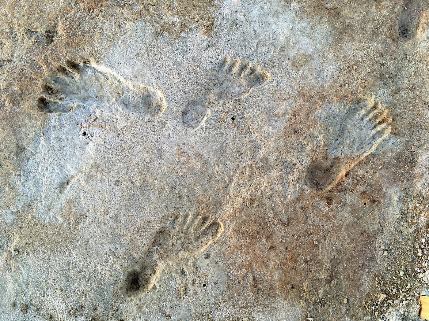
The White Sands site, in the Tularosa Basin, is no ordinary find. There are no worked bones here, no hearths, no carefully shaped stone points. Only traces: the fleeting mark of a heel, the curve of a toe, the press of a sole into sodden ground. And yet these immaterial relics often say more than any tool. A footprint is a captured instant, the gesture of a living being seized in mid-movement more than twenty thousand years ago. It is, quite literally, an encounter.1
An ocean of gypsum born from a vanished lake
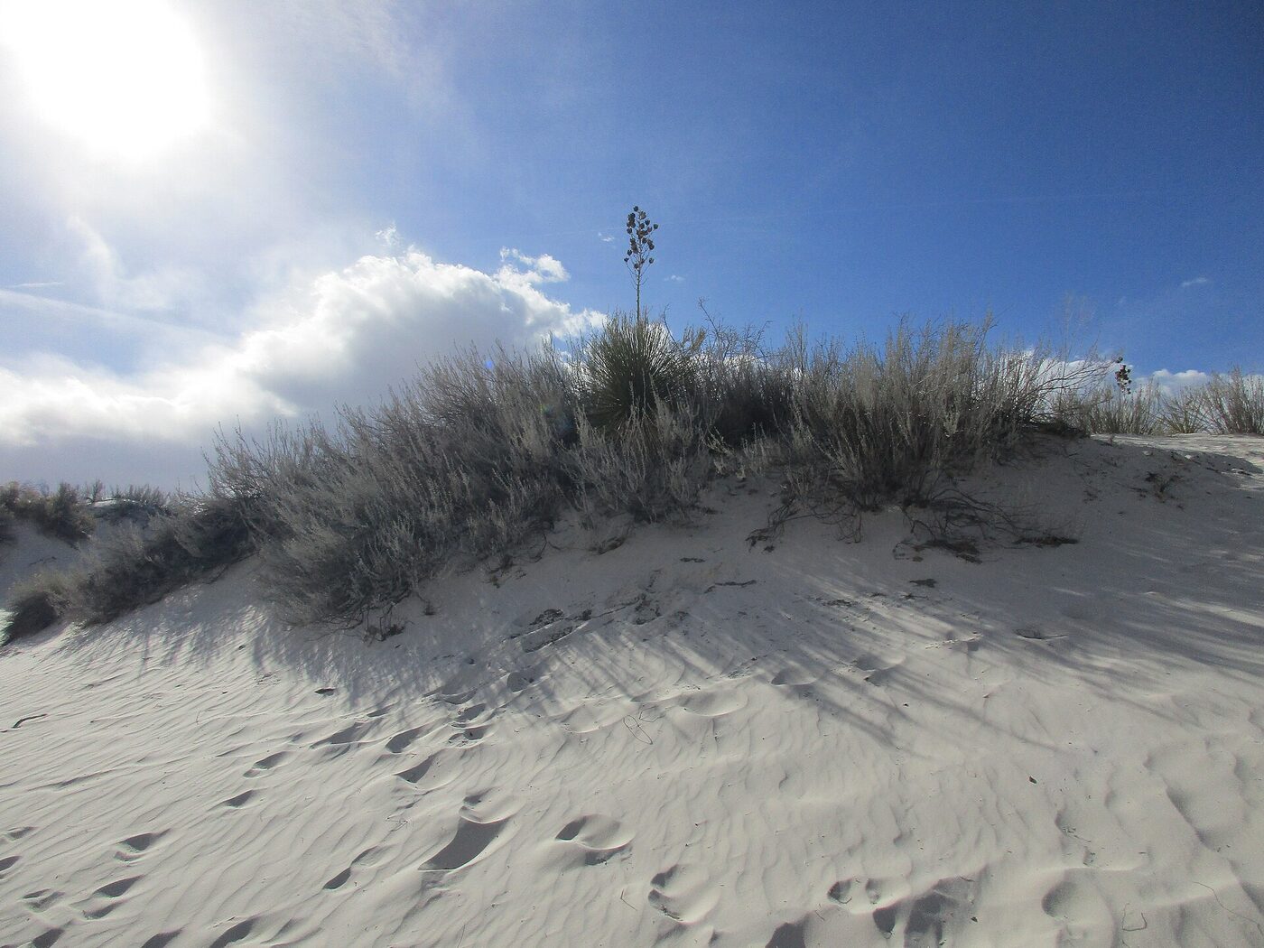
White Sands National Park protects the largest gypsum dune field on Earth: roughly 700 square kilometres of calcium sulphate crystals ground by erosion into grains of extreme fineness. As far as the eye can see, white waves ripple under the sun, so pale they cast back an almost lunar light. Unlike ordinary quartz sand, gypsum is water-soluble; it should never accumulate into dunes. That it does so here is owed to a singular geography: the Tularosa Basin is a closed bowl with no outlet to the sea, framed by the San Andres Mountains to the west and the Sacramento Mountains to the east.
To understand the footprints, one must travel back to the last ice age, the Upper PalaeolithicPalaeolithicThe oldest and longest period of prehistoryPrehistoryThe span of human history before the invention of writing, from the Palaeolithic to the Metal Ages, known mainly through material remains.→ (c. 3.3 Ma–12,000 BC), defined by chipped stone tools and a hunter-gatherer way of life.→. At that time the climateClimateThe long-term average atmospheric conditions of a region; its variations (glaciations, aridifications) shaped migrations, agriculture and the collapse of prehistoric societies.→ of the American Southwest was far wetter and cooler than today. Where an immaculate desert now stretches, there lay a vast shallow lake, Lake Otero, fed by meltwater and rain. Its marshy shores, mudflats and channels formed a wetland landscape teeming with life. It was on those muddy banks, at the water's edge, that living beings, human and animal, left the imprint of their passage.2
When Lake Otero dried up at the end of the glaciation, its gypsum-rich sediments were laid bare, then reworked by the wind into the dunes we admire today. But beneath certain parts of the basin, where the ground consolidated, layers of hardened mud kept intact the prints stamped into them millennia earlier. Park palaeontologists had long known of what they nicknamed the "ghosts": prints that appear only under particular moisture conditions, surfacing and fading with the seasons like spectres rising to the surface of the desert.
The preservation of these footprints hinges on a delicate chain of circumstances. For a step to fossilise, the ground must be wet enough to record the mark of the foot, yet firm enough not to collapse at once. The print must then dry and harden before being covered by a fresh deposit, sediment carried by a flood, a veil of precipitated carbonate, a layer of mud, that seals it without destroying it. On the shore of Lake Otero, the alternation of wet and drying phases, together with the peculiar chemistry of waters laden with gypsum and carbonate, created the ideal conditions for this petrification. Each preserved print is thus the product of a fortunate geological accident, and their number at White Sands, counted in the thousands, is all the more exceptional.
The landscape these walkers had before their eyes was nothing like a desert. Where today's traveller sees only a dazzle of white sand and a few clumps of yucca, there stretched a mosaic of wet meadows, reed beds and shallow bodies of water. Herds of grazers came to drink and browse; predators prowled. It was, in short, a major watering place in a cooler, greener American Southwest, a gathering point for wildlife where humans too, naturally, came in search of game, water and resources. The density of human and animal prints is explained by this oasis function: nearly everyone, in the end, passed through.
The discovery of the footprints
Fossil traces had been spotted in the Tularosa Basin as early as the 1930s, and researchers gave them intermittent attention across the decades. But it was in the 2000s and 2010s that scientific interest crystallised, when teams began to systematically document the thousands of prints surfacing in the area, many of them on military land adjacent to the park, the White Sands Missile Range. The ground yielded a veritable fossil bestiary: tracks of mammoths, giant ground sloths, prehistoric camels, dire wolves (Canis dirus), big cats. And, mingled among them, unmistakably human prints.2
The decisive fieldwork was led by an international team bringing together researchers from the U.S. Geological Survey, the National Park Service and several universities, including Bournemouth in the United Kingdom, which specialises in the study of fossil footprints. On a restricted sector along the old lakeshore, the scientists uncovered several alignments of human steps forming genuine trackways: sequences of successive prints allowing one to follow, step by step, an individual moving across the soft ground. Some of these trackways extend over tens of metres.
Analysis of the prints' morphology immediately revealed a remarkable fact: most of them had been left by young individuals, teenagers and children. Adult feet were clearly in the minority. This juvenile predominance, which we shall detail below, is one of the most moving and intriguing signatures of the site.
The technique used to study these prints deserves emphasis, for it illustrates the sophistication of contemporary palaeoichnology, the science of fossil traces. Rather than simply photographing the tracks, researchers turn to photogrammetry: hundreds of images taken from every angle are assembled by computer into a three-dimensional model of each print accurate to a tenth of a millimetre. This digitisation makes it possible to analyse the depth of the step, the distribution of pressure, the angle of heel strike or the push of the toes, all clues to the mass, speed and even physical state of the walker. It also creates a permanent digital archive of prints that, once exposed to air and wind, degrade quickly.
That fragility is a constant concern. Many of the White Sands prints are visible only intermittently: a change in moisture, a downpour, a dry spell, and the "ghosts" appear or vanish. Teams must act fast, within sometimes narrow windows, to document the trackways before they fade again. The location of part of the site on an active military range adds considerable logistical constraints, but has also, paradoxically, shielded the area from development and looting.
The 2021 dating: the Ruppia seeds
A footprint contains in itself no directly datable material. To assign it an age, one must date the sediment layers bracketing it: the stratum the foot pressed upon, and the one that later came to cover and sealSealA small engraved object (often steatite) used to stamp a mark in clay; the Indus seals, bearing animals and signs, attest to administration and trade, though their script remains undeciphered.→ it. If the age of those levels can be established, the age of the print itself is bracketed.
Now, in the White Sands sediments, researchers had an ideal organic material for radiocarbonRadiocarbon (carbon-14)A dating method based on the decay of carbon-14, usable back to about 50,000 years.→ dating: fossil seeds of an aquatic plant, the spiral ditchgrass (Ruppia cirrhosa), a submerged grass that grew in the shallow waters of Lake Otero. These tiny seeds, sandwiched in the layers above and below the trackways, offered a direct means of chronologically bracketing the human prints.
The results, published in the journal Science in September 2021, landed like a bombshell. Radiocarbon dating of the Ruppia seeds indicated that the prints had been stamped within a window of roughly 23,000 to 21,000 years before present. In other words, at the very heart of the Last Glacial MaximumLast Glacial MaximumThe peak of the last glaciation (c. 26,000 to 19,000 years ago), with ice sheets at their greatest extent; it pushed populations towards southern refuges.→, the moment when the Northern Hemisphere ice sheets reached their greatest extent.1
To grasp the import of this announcement, one must recall what the textbooks taught at the time. According to the dominant model, known as "Clovis first," the first Americans arrived around 13,000 years ago, by way of a passage opening through the Canadian ice. A human presence attested at 23,000 years thus placed human beings in North America nearly ten thousand years earlier than the consensus allowed, and, crucially, before the ice even reached its peak, when the supposed migration routes were meant to be blocked.
The controversy: the reservoir effect of aquatic plants
A discovery of such magnitude could not fail to draw scepticism. Scientific rigour demands it: the more extraordinary a claim, the more solid the evidence must be. And the criticism here quickly converged on one precise and technically formidable point: the reliability of the radiocarbon dating of the Ruppia seeds.
The problem has a name: the reservoir effect, sometimes called the hard-water effect. Radiocarbon dating rests on the steady decay of carbon-14, a radioactive isotope that every living organism absorbs from its environment while alive, and which decays at a known rate after death. By measuring the remaining carbon-14, one works back to the date of death. But this calculation assumes that the organism drew its carbon from the atmosphere, whose carbon-14 content is well calibrated.
Aquatic plants like Ruppia, however, do not take their carbon from the air, but from the carbon dissolved in the water around them. And that water, in the Tularosa Basin, flows through terrain rich in ancient limestone, geologically very old calcium carbonate, devoid of carbon-14 since all of its own decayed hundreds of millions of years ago. By absorbing this "dead" carbon, the plant can appear artificially older than it really is. A Ruppia seed that grew fifteen thousand years ago might, for instance, yield a radiocarbon date of twenty thousand years.3
Several research teams therefore raised this objection in earnest: what if the ages obtained at White Sands were overestimated by several thousand years because of this reservoir effect? The prints would then be younger, perhaps far younger, than the announced 21,000 to 23,000 years. The debate was launched, and it was perfectly legitimate. Everything rested on a single dating method, applied to a notoriously treacherous material. To carry the conviction of the scientific community, independent evidence obtained by other routes was needed.
The difficulty of the problem must be appreciated to understand why the debate ran so hot. The exact magnitude of a reservoir effect is not a constant: it depends on local geology, the composition of the water, the depth at which the plant grows, and can vary from one point of the same lake to another and from one epoch to the next. One cannot simply apply a flat correction to "rejuvenate" the dates: one would need to know precisely the dead-carbon content of Lake Otero's water at each moment considered, which is beyond reach. This irreducible uncertainty is what made the objection so awkward, not because it proved the dates wrong, but because it prevented one from proving them right so long as one relied on Ruppia alone.
The 2023 confirmation: conifer pollen and quartz grains
This is precisely what the White Sands team set out to provide. Rather than defending its initial dating at all costs, it chose to test it by mobilising two methods entirely independent of the aquatic-plant radiocarbon. The results, published in Science in October 2023, converged spectacularly.3
The first cross-check rested on pollen. From the same sediment layers researchers extracted conifer pollen grains, notably pine, terrestrial plants which do capture their carbon from the atmosphere and so wholly escape the hard-water reservoir effect. Radiocarbon dating this terrestrial pollen amounted to consulting an independent clock, immune to the criticism raised against the Ruppia seeds. The technical challenge was considerable: tens of thousands of pollen grains had to be isolated through painstaking sorting to gather a mass sufficient for a reliable measurement. The effort paid off: the dates obtained on the conifer pollen agreed with those of the seeds, confirming an age of roughly 21,000 to 23,000 years.
The second cross-check called on a radically different technique, optically stimulated luminescence (OSLLuminescence (OSL)Optically stimulated luminescence datingLuminescence datingA method dating the last heating or light exposure of sediments and minerals by measuring energy trapped in the crystal.→: measures the last exposure of sediment grains to light.→). This method does not measure carbon, but the last exposure of mineral grains to sunlight. When quartz grains are buried and shielded from light, they accumulate in their crystal lattice an energy due to the ambient natural radioactivity. By stimulating these grains in the laboratory with controlled light, this energy is released as luminescence, whose intensity allows one to calculate how long the grains have been buried, that is, how long since they last saw daylight.
Applied to the quartz grains of the White Sands sediments, OSL dating indicated a minimum age of roughly 21,500 years for the relevant layers. Three independent methods, radiocarbon on aquatic seeds, radiocarbon on terrestrial pollen, and luminescence on quartz, now pointed to the same interval. Such convergence, achieved by techniques resting on unrelated physical principles, is the most powerful argument science possesses for establishing a date. The reservoir-effect objection, serious and legitimate, was thus defused. The White Sands footprints had indeed been stamped more than twenty thousand years ago.1
There is also a methodological moral to draw from the Ruppia episode, one that reaches well beyond this single site. The history of dating the human past is, in large part, a history of learning which materials can be trusted and under what conditions. Marine shells, freshwater snails, lake plants, bone collagen of varying preservation, each carries its own pitfalls, its own potential offsets. The reservoir effect that clouded the first White Sands dates is a textbook case of a problem that experts had long anticipated in principle, but whose practical resolution required ingenuity and labour. That the team answered it not by argument but by hauling in two independent clocks is precisely what turned a contested claim into a robust one.
What the tracks tell us: children at the water's edge
Beyond the chronological feat, the White Sands footprints offer something infinitely rare in prehistory: direct access to behaviour, to the lived gesture. A worked stone tells us about a technique; a footprint brings us into the presence of an individual, in a precise moment of their life. And what the analysis of the human trackways at White Sands reveals is at once intimate and arresting.
The most striking fact, as noted, is the predominance of the young. The great majority of the prints were left by children and teenagers. Several interpretations have been proposed. The simplest holds that the youngest frequented the shores in greater numbers, perhaps engaged in gathering or carrying tasks around the camp, while the adults busied themselves elsewhere. Another hypothesis stresses that, on soft and heavily trampled ground, the shallow prints of heavier adults could be erased by repeated passage, where the lighter steps of children were better preserved in certain mud conditions.
One of the site's most famous trackways tells almost a complete scene. Over more than a kilometre and a half, a long trail shows a person, probably a young woman or a teenager, walking briskly across the sodden ground. In places the trail is accompanied by tiny prints: those of a very young child, carried and then set down at intervals, as if the adult had propped an infant on one hip, set it down for a moment's rest, then picked it up again. On the return, a few hours later it seems, the same person retraces the path in reverse, this time without the child. There, etched in the mud, one reads a round trip, a mission accomplished, a fragment of everyday life twenty thousand years old.2
More extraordinary still: at one point, this person's trail crosses that of a giant ground sloth. The human track cuts across the animal's, and the arrangement of the prints suggests the sloth reacted to the human presence, turning, perhaps rearing up on its hind legs in a defensive posture. At another point on the site, human prints follow those of a Columbian mammoth. These interweavings of tracks are the oldest known direct evidence of interactions between humans and North America's vanished megafaunaMegafaunaThe very large animals (mammoths, giant ground sloths, etc.) of the PleistocenePleistoceneThe geological epoch of the great ice ages (c. 2.6 Ma–11,700 BP), spanning most of human prehistory.→, most of which became extinct at the end of the last ice age.→.
The study of print proportions also allows the stature and gait of the walkers to be estimated. Foot length, arch width, the distance between two successive steps yield indications of height and walking speed. Some trackways attest to a leisurely walk, others to a brisk pace, almost a run. Researchers have even identified moments where the walker slips slightly on the mud, recovers balance, or skirts an obstacle invisible today but which must then have cluttered the shore. This level of behavioural detail, accessible nowhere else with such precision, makes White Sands a unique window not onto what these humans made, but onto what they did, instant by instant.
Stalking the giant: human prints and megafauna
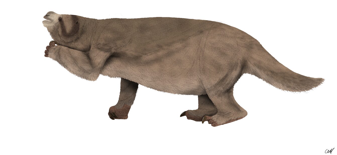
The giant ground sloth bears no resemblance to the placid tree-dwelling sloth of today's tropical America. The Pleistocene species, such as Mylodon or the gigantic Megatherium, were massive herbivores, some reaching the size of an elephant and weighing several tonnes, armed with formidable claws. At White Sands, fine analysis of the trackways showed that humans deliberately followed the tracks of one of these animals, adjusting their own course to that of the beast.
The prints reveal a genuine choreography: the sloth, aware of being followed, stops, wheels around, rears onto its hind legs, one can make out the broad print left by the animal as it pivots. The humans, for their part, seem to approach it warily, perhaps to harass or divert it. Is this a coordinated hunt, an attempt to bring the animal down, or merely a game of pursuit and avoidance? The tracks do not allow a certain answer. But they document, with unprecedented precision, that the humans of this era actively shared their world with these giants and knew how to approach them.
This behavioural dimension makes White Sands a site without equal. Elsewhere, the interaction between humans and megafauna is inferred indirectly: bones bearing cut marks, projectile points lodged in a carcass, bone accumulations at a kill site. Here, one observes the interaction itself, in motion, as it unfolded, a scene of hunting or confrontation frozen in the sediment, without a single artefact, nothing but steps.
These scenes raise a fascinating question about the cognitive and social capacities of the humans of this era. To methodically follow a large animal's trail, anticipate its reactions, adapt one's approach, presupposes a fine knowledge of the prey's behaviour and probably some form of coordination between several individuals. The presence of children's prints near some of these trails has even led some researchers to wonder whether the youngest accompanied the adults on these approaches, or watched from a distance, learning a vital skill by imitation. Whatever the case, these tracks paint the picture of a fully accomplished humanity, master of its environment, capable of standing up to animals weighing several tonnes.
The "Clovis first" model called into question
To grasp why White Sands shakes American archaeology, one must understand the theoretical edifice it cracks. For most of the twentieth century a solid consensus reigned: the "Clovis first" model. It takes its name from the town of Clovis, in New Mexico, where in the 1930s characteristic stone points were discovered, finely worked and fluted, associated with mammoth remains. These Clovis points, dated to about 13,000 years, were found across a vast North American territory, and were taken to mark the arrival of the first Americans, who came from Asia via the Bering Strait.
The classic scenario holds in a few propositions. During the glaciation, sea level, lowered by water locked in the ice caps, had exposed Beringia, a land bridge linking Siberia to Alaska. Palaeolithic hunters are thought to have crossed it, reaching Alaska. But to reach the heart of the continent they had to cross a wall of ice: the two immense North American ice sheets, the Cordilleran to the west and the Laurentide to the east, which merged into an impassable barrier. Only with warming, around 13,000 to 14,000 years ago, would an ice-free corridorIce-free corridorAn inland passage between the Laurentide and Cordilleran ice sheets, open and viable only around 14,000-13,000 years ago, too late for the earliest arrivals.→ have opened between them, a passage allowing the descent southward. Clovis marked, it was thought, this first irruption.1
It is hard to overstate how entrenched this framework became. For two or three generations, "Clovis first" functioned less as a hypothesis to be tested than as a baseline against which all claims of earlier human presence were measured, and, more often than not, dismissed. Sites that yielded older dates were scrutinised for contamination, for misidentified strata, for stone "tools" that might in fact be natural breakage. This demanding standard was, in itself, good science: extraordinary claims do require extraordinary evidence. But it also created a powerful inertia, an expectation that no one could have reached the Americas before the corridor opened. White Sands, with its footprints that no one can dismiss as natural artefacts, confronted that inertia head-on.
This model, elegant and long dominant, had already begun to crack before White Sands. Sites such as Monte Verde, in southern Chile, dated to about 14,500 years, had brought convincing evidence of a human presence predating Clovis, and what is more, far to the south, which implied an even earlier peopling further north. Other sites, in the United States and elsewhere, suggested pre-ClovisPre-ClovisA set of American sites older than Clovis (Monte Verde, Cooper's Ferry, etc.) that overturned the 'Clovis first' model.→ dates. The "Clovis first" consensus was already crumbling, gradually replaced by the idea of an older and more complex peopling.
But White Sands strikes far harder. At 21,000 to 23,000 years, the site does not push the date back by a few centuries: it sets it back nearly ten millennia relative to Clovis, and places a human presence in the very midst of the Last Glacial Maximum. Now, at that precise moment, the ice sheets were at their peak and the ice-free corridor did not yet exist: it would not open until thousands of years later. How, then, did these humans reach so far south, when the classic route was closed?
The peopling routes: inland corridor or Pacific coast
This geographical riddle gave new weight to a long-marginal hypothesis: that of the Pacific coastal routePacific coastal routeThe hypothesis of a migration along the deglaciated Pacific coast (the 'kelp highway'), exploiting marine resources; favoured for the earliest arrivals.→, sometimes nicknamed the "kelp highway." According to this model, the first Americans did not wait for the opening of a continental passage. They are thought to have skirted the continent's west coast, advancing step by step along the Pacific shoreline, exploiting the abundant marine resources, fish, shellfish, sea mammals, birds, of rich coastal ecosystems, whose underwater kelp forests formed the nutritional foundation.
This maritime and littoral route had a decisive advantage: it remained passable even at the height of the glaciation, by boat or on foot along ice-free coastal zones and islands. It would have allowed populations to bypass entirely the lock of the inland ice sheets and descend rapidly southward, well before the land corridor became passable. The human presence at White Sands as early as 23,000 years fits far better with this coastal scenario than with that of the inland corridor.2
The chief difficulty of the coastal hypothesis lies in its near-invisibility to archaeology. Since the end of the glaciation, sea level has risen by more than a hundred metres, swallowing the ancient shorelines where these pioneers would have lived. The camps, the hearths, the shell middens that lined their route now lie under tens of metres of water, along the drowned continental shelf. Directly proving the coastal route therefore demands difficult underwater archaeology, which is why the clues remain fragmentary. White Sands, by attesting a very early inland presence, provides indirect but powerful evidence that a peopling predating the corridor did indeed take place.
Another equally dizzying question arises: when, exactly, did the crossing of Beringia occur? If humans were already treading New Mexico 23,000 years ago, their crossing of the Bering bridge must be older still, perhaps 26,000, 30,000 years or more. Some genetic studies evoke a long phase of isolation of Native American ancestors in Beringia itself, a "Beringian standstill" during which populations would have lingered for millennia on the land bridge before continuing their journey south. White Sands does not settle these debates, but it makes the hypothesis of a very ancient human presence in the Americas markedly more credible.
Beyond the coast and the corridor, some researchers have even floated bolder scenarios still, such as an arrival by sea from other regions, but these hypotheses remain highly speculative and largely marginal. The bulk of today's debate pits two great routes, the inland and the coastal, against each other, without their being necessarily mutually exclusive: it is entirely conceivable that several routes were taken at different times, by different groups, over several millennia. The peopling of an entire continent was surely not a single event, but a drawn-out process of advances, retreats and multiple routes.
Significance and lingering debates
However solid the dating has become after the 2023 confirmations, scientific caution remains in order. A few researchers continue to stress the difficulties inherent in dating such sediments, and call for multiplying independent analyses. This is the normal march of science: a discovery of this importance must be tested, replicated and discussed for years before being fully integrated into knowledge. But the convergence of three distinct methods has considerably strengthened the authors' position, and the age of the prints now enjoys broad, if not unanimous, assent.
If one accepts this dating, the implications are profound. It implies first that modern humans were present in North America millennia before believed, and that they lived there throughout the glacial peak, in harsh environmental conditions. It suggests next that the Clovis culture, long held to be founding, was in fact late, the product of an already ancient peopling and not its starting point. It invites, finally, a wholesale rethinking of the rhythms, routes and modalities of our species' conquest of the New World.
Another, quieter debate concerns the fate of these very early populations. Did they leave descendants among today's Native Americans, or do they represent a pioneer wave extinguished without genetic posterity, replaced by later migrationsMigrationsLong-distance movements of populations; a major driver of human history (the exit from Africa, the peopling of continents, Neolithic and steppe expansions).→? The available genomic data do not yet allow the White Sands walkers to be clearly linked to known Native American populations. It may be that several waves of peopling succeeded one another, some leaving little trace in the contemporary genetic heritage. Here too, the site poses more questions than it resolves, which, in science, is the sign of a fruitful discovery.
The discovery also carries a resonance beyond the strictly academic frame. For many Native American nations, the idea that their ancestors have occupied this continent since time immemorial is part of a knowledge handed down from generation to generation, sometimes in tension with the shorter scientific chronologies inherited from the Clovis model. By pushing the human presence well beyond thirteen thousand years, White Sands brings, on this point, the conclusions of archaeology closer to the temporal depth claimed by certain Indigenous traditions. This convergence, without being a direct validation of the oral narratives, invites a more respectful dialogue between the different forms of memory of the past.
Finally, one must place White Sands within the long span of human history. These footprints date from the Upper PalaeolithicPalaeolithicThe oldest and longest period of prehistory (c. 3.3 Ma–12,000 BC), defined by chipped stone tools and a hunter-gatherer way of life.→, well before the HoloceneHoloceneThe current geological epoch, begun about 11,700 years ago at the end of the last ice age; the setting of all post-glacial history.→, the present interglacial era in which agricultureAgricultureThe cultivation of plants and production of food by working the soil, which emerged in the Neolithic in the Near East and independently elsewhere; it radically transformed human societies.→, cities and writingWritingA system of conventional signs used to fix language or information durably; its appearance (c. 3300 BC) marks, by convention, the end of prehistory.→ would be born. The walkers of Lake Otero were nomadic hunter-gatherersHunter-gatherersA way of life based on hunting, fishing and gathering wild resources, without farming or herding; it dominated almost the whole of human history.→ living in a glacial world peopled by mammoths and giant sloths, a world that would vanish with post-glacial warming and the extinction of the megafauna. Their steps reach us from that bygone universe as a message of astonishing precision.
The fragility of the prints lends the whole enterprise a quiet urgency. Each documented trackway is, in a sense, a rescue: a record snatched from a surface that the next season's weather may erase. The "ghosts" of White Sands are not a permanent monument but a slowly vanishing manuscript, and the science built upon them is a race against the very desert that preserved them.
Conclusion: footprints that rewrite a history
There is something profoundly unsettling about contemplating a footprint twenty-three thousand years old. Where stone tools hand us an object, the footprint hands us an instant. In it one senses the weight of a body, the haste or slowness of a gait, the carrying of a child, the chance meeting with a large animal. At White Sands, an entire anonymous people resurfaces from the ground, not through its bones or its weapons, but through the trace of its bare feet pressed into the mud of a vanished lake.
It is worth dwelling, too, on the human scale of what these tracks preserve. We are accustomed to meeting the deep past through objects emptied of their owners, a flintFlintA hard, brittle siliceous rock, knapped by prehistoric people to produce blades, points and sharp tools.→ with no hand, a hearth with no fire-tender, a grave with no mourners. White Sands restores the missing person. The walker who slowed, shifted a child from one hip to the other, glanced back at a stirring sloth and pressed on: these are not inferences drawn from debris but acts read almost in real time, the closest thing prehistory offers to watching someone live. That intimacy is part of why the site has captured the public imagination far beyond the usual circles of specialists, and why its dating has been scrutinised with such intensity.
At bottom, the scientific adventure of White Sands holds a lesson: a trace, however fleeting, can weigh more than a monument. No monumental tomb, no prestigious tool was needed to shake a century-old paradigm; a few bare footprints, dated with obstinate rigour, sufficed. This site reminds us that prehistory is read not only in the objects humans made, but also in the involuntary marks they left while living, walking, hunting, carrying their children at the water's edge.
The site's scientific significance is immense: it provides, to date, the most convincing evidence of a human presence in the Americas long before Clovis, at the very heart of the last glaciation. The initial controversy over the Ruppia seed reservoir effect, far from being a failure, illustrates on the contrary the strength of the scientific process: a legitimate objection was raised, then resolved by independent methods, conifer pollen and OSL on quartz, which confirmed the dating. This is how knowledge advances: through doubt, testing and the convergence of evidence.
What remains is the essential, which transcends quarrels over chronology. Somewhere on the shore of a glacial lake, under a New Mexico sky that predates the deserts, children ran, a young mother carried her infant, a hunter followed a giant with measured steps. Twenty-three thousand years later, their steps still surface, white ghosts beneath the gypsum, reminding us that the history of humanity in the Americas begins far earlier, and far more humanly, than we had imagined.
Je télécharge les images pour ma veille visuelle. Le traitement éditorial est vraiment soigné.
C'est dingue de se dire que tout ça s'est passé il y a aussi longtemps.
Ce qui me touche, c'est de voir que le geste technique existe depuis si longtemps. La main qui travaille, c'est universel.
Des empreintes humaines de 21 000 ans au Nouveau-Mexique, c'est quelque chose qu'on imagine mal. Ces gens marchaient là pendant la dernière grande glaciation, quand des kilomètres de glace couvraient le nord du continent. Comment ont-ils survécu, comment ont-ils atteint ces latitudes ? Ces questions sur le peuplement des Amériques sont de vrais romans d'aventure.
Les empreintes de White Sands au Nouveau-Mexique ont fait sensation en archéologie américaine car elles repoussaient la date d'arrivée des humains aux Etats-Unis à plus de 21 000 ans. Ces empreintes dans un paléo-lac asséché constituent des preuves directes de présence humaine, sans ambiguité possible. Si la datation est confirmée, elle implique une présence humaine en Amérique pendant le Dernier Maximum Glaciaire.