Au bord de la route qui relie Maroua a Garoua, dans la region du Nord-Cameroun, un champ de marbre se deploie dans le paysage semi-aride. Sur ses dalles blanches, rosees ou verdatres, quelque 500 figures geometriques ont ete gravees par des mains humaines -- il y a peut-etre trois siecles, peut-etre trois millenaires. Le site de Bidzar, signale pour la premiere fois en 1933, demeure l'un des ensembles de petroglyphes les plus enigmatiques et les moins connus d'AfriqueAfriqueContinent berceau de l'humanité : les premiers hominines y apparaissent, puis Homo sapiens il y a environ 300 000 ans, avant l'expansion vers le reste du monde.→ centrale.
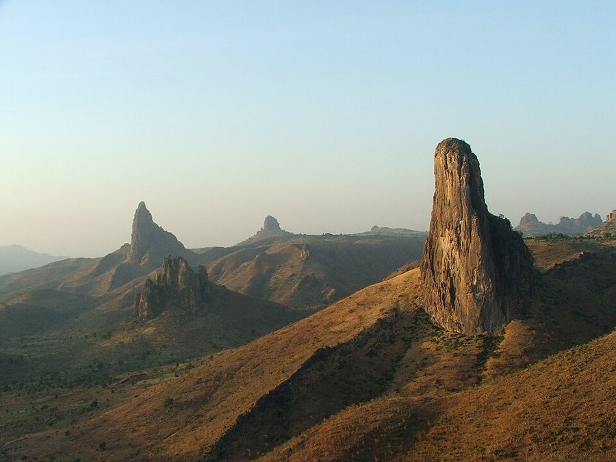
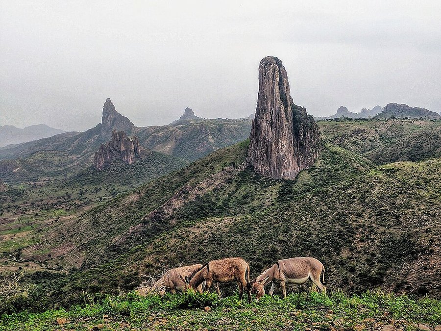
Bidzar (parfois orthographie Bitzar) est un village situe dans le departement du Mayo-Louti, dans la region du Nord, peuple en majorite de Guidar avec quelques familles Moundang et Guiziga. A l'ouest de la route principale, un affleurement de marbre calcaire de type cipolin s'etend sur plusieurs kilometres carres. Ce marbre -- traverse de filons de chloritoschistes qui lui conferent des teintes vert, rose ou bleuatre -- presentait des caracteristiques ideales pour la gravure : surface relativement tendre, plans subhorizontaux et uniformes propices au trait. C'est a l'embranchement de la route vers Guider que les dalles gravees se concentrent, sur une zone de 2,5 km du nord au sud et 1 km d'est en ouest.[1]
Des geometries en marbre : description des oeuvres
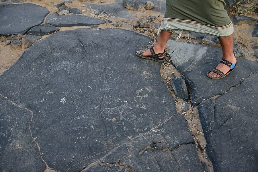
Toutes les gravures de Bidzar presentent des caracteres geometriques : cercles tangents, emboites ou sécants, cercles concentriques, figures hachurées, reseaux lineaires. On y trouve aussi des cupules -- simples cuvettes creusees dans la roche, l'une des formes les plus universelles de l'art rupestre mondial -- ainsi que des motifs que certains chercheurs interpretent comme des representations schematiques d'objets ou d'etres vivants.
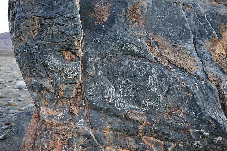
La technique utilisee est celle de la percussion indirecte punctiforme : un percuteur est pose sur la surface de marbre, puis frappe avec un marteau, detachant un eclat ponctuel. La repetition de ces coups crees le trait desire. Les artisans ont systematiquement choisi les surfaces les plus uniformes et les moins erodees, evitant les zones lapiezees ou cannelurees. Pres de 500 representations ont ete denombrees sur l'ensemble du site, reparties sans organisation apparente sur les dalles -- mais avec des recurrences thematiques qui suggerent une intention commune.
Une datation qui defie les methodes modernes
La datation des gravures de Bidzar constitue l'un des principaux defis scientifiques. Aucune datation radiometrique n'a pu etre obtenue : le marbre ne contient pas de matiere organique directement associee aux gravures, et les techniques de datation par OSL (luminescence) ou par mesure du vernis rupestre restent difficiles a appliquer sur ce type de support.
L'estimation actuelle repose sur l'attenuation chimique du support calcaire : plus le marbre est degrade autour des gravures, plus celles-ci sont anciennes. Ce raisonnement, impreche mais possible, conduit a une fourchette tres large : de 300 a 3 000 ans. Certaines gravures pourraient donc remonter aux premiers siecles de notre ere, durant les royaumes de savane qui precederent l'islam dans la region ; d'autres pourraient n'avoir que quelques siecles. La stratification des motifs -- certains recoupant ou surimposant d'autres -- indique clairement des occupations multiples et succesives du site.
Un site unique en Afrique centrale
Ce qui rend Bidzar exceptionnel, c'est l'absence de tout equivalent connu au Cameroun. Contrairement aux grandes traditions rupestres d'Afrique du Nord (Tassili n'Ajjer, Ahaggar) ou d'Afrique australe (San, Drakensberg), ou les representations sont souvent figuratives -- animaux, humains, scenes de chasse -- Bidzar offre un repertoire exclusivement geometrique et abstrait. Cela rapproche ce site des traditions rupestres de l'Ogoue (Gabon), egalement caracterisées par des figures geometriques, bien que les supports et les themes soient differents.
Alain Marliac, qui a mene les premieres fouilles systematiques du site dans les annees 1970-1980, a ete le premier a documenter rigoureusement les gravures et a proposer une interpretation. Selon lui, leur recurrence et leur organisation suggerent qu'elles etaient liees a des representations mythiques ou cosmo-goniques, peut-etre a un systeme de communication proto-scriptural ou a des pratiques rituelles dont les populations Guidar actuelles n'ont plus memoire. Le sens de ces oeuvres s'est perdu avec les civilisations qui les ont produites.
Menaces et perspectives de preservation
Le site de Bidzar fait face a des menaces serieuses. Le marbre calcaire qui sert de support aux gravures est egalement la matiere premiere des usines de cimenterie locales et des carrieres artisanales. Des decennies d'exploitation intensive ont reduit la superficie des affleurements et fragmente irremediablement certaines dalles. L'erosion naturelle accentue cette degradation.
En 2018, le Ministere des Arts et de la Culture du Cameroun a soumis le site a la liste indicative du patrimoine mondial de l'UNESCO, sous le critere (i) -- chef-d'oeuvre du genie createur humain -- reconnaissant ainsi la valeur universelle de ces gravures. Cette inscription indicative ne protege pas encore le site de facon contraignante, mais constitue un premier pas vers une protection juridique plus forte.
D'autres sites de la region sont egalement en cours de prospection : les falaises du Tinguelin, la montagne Makabai pres de Maroua, et plusieurs formations rocheuses du Diamaré presentent des dessins enigmatiques dont l'origine et le sens restent a elucider. La prehistoire du Nord-Cameroun n'a sans doute pas encore revele tous ses secrets -- et c'est pres de Bidzar, au bord d'une route poussiereuse, que se lisent les premieres lignes de cette histoire encore largement inconnue.
Les traditions rupestres d'Afrique centrale et occidentale : un panorama
Les petroglyphes de Bidzar ne sont pas un phenomene isole : ils s'inscrivent dans un ensemble plus vaste de traditions d'art rupestre qui couvrent l'Afrique centrale et occidentale, des rives du lac Tchad aux forets gabonaises, des plateaux du Niger au piedmont des monts Mandara. Ce panorama continental, encore imparfaitement documente faute de ressources suffisantes pour la recherche systematique, revele une diversite de pratiques graphiques qui reflete la richesse culturelle de cette partie du monde souvent sous-representee dans les syntheses prehistoriques mondiales.[6]
Au Nigeria, les sites de Birnin Kudu dans l'Etat de Jigawa ont livre des gravures rupestres associant motifs geometriques et representations animalistes qui evoquent par certains aspects les traditions sahariennes du Niger et du Tchad. Dans la region de l'Aïr, au Niger, les gravures parietales datant du Neolithique saharien (8000-3000 av. J.-C.) offrent un repertoire iconographique extraordinairement riche en representations bovines -- temoignage d'un pastoralismePastoralismeMode de vie fondé sur l'élevage de troupeaux (bovins, ovins, caprins), souvent mobile, qui s'est répandu au Sahara « vert » et a précédé, dans cette région, l'agriculture proprement dite.→ florissant dans un Sahara alors verdoyant -- qui contraste avec l'abstraction geometrique predominante a Bidzar. Ces differences de style et de sujet refletent probablement des traditions culturelles distinctes autant que des contextes ecologiques differents.
Le massif de l'Ennedi au Tchad, classe au Patrimoine mondial de l'UNESCO en 2016, constitue l'un des ensembles d'art rupestre les plus spectaculaires d'Afrique centrale. Les peintures et gravures de l'Ennedi couvrent plusieurs millenaires, des representations les plus anciennes de bovins et de chasseurs jusqu'aux scenes de cavaliers arabes datant des derniers siecles. La richesse figurative de l'Ennedi s'oppose radicalement a l'abstraction de Bidzar, suggerant des fonctions symboliques et des univers cognitifs differents, bien que les deux traditions soient geographiquement voisines a l'echelle du continent.
En Republique centrafricaine, dans la region de Bangui et dans les massifs rocheux de l'Ouest, des petroglyphes encore peu etudies presentent des cupules et des motifs geometriques qui rappellent ceux de Bidzar, suggerant peut-etre une aire culturelle commune ou des traditions paralleles. Au Gabon, les gravures de la vallee de l'Ogooue -- documentees des le XIXe siecle par des explorateurs et plus systematiquement depuis les annees 1980 -- offrent des exemples de figures anthropomorphes et geometriques qui illustrent la permanence de la pratique rupestre dans les environnements forestiers equatoriaux, contexte tres different des milieux semi-arides du nord Cameroun.[6]
La distinction fondamentale entre traditions figuratives -- privilegiant les representations d'animaux et d'humains, comme dans le Sahara pastoral -- et traditions abstraites -- privilegiant les motifs geometriques, les cupules et les reseaux lineaires, comme a Bidzar -- n'est pas strictement geographique : elle traduit des choix symboliques et culturels que les archeologie se s'efforcent de dechiffrer. Ces choix pourraient refleter des differences dans les fonctions assignees a l'art rupestre (propitiation cynenetique, marquage territorial, communication rituelle) autant que des traditions stylistiques propres a des groupes culturels specifiques.
Les expeditions scientifiques de 1933 a nos jours
L'histoire de la recherche archeologique sur les petroglyphes de Bidzar est etroitement liee a l'histoire coloniale et postcoloniale du Cameroun, et reflete les opportunites et les limitations successives de l'investigation scientifique dans cette partie de l'Afrique centrale. Le premier signalement officiel du site dans la litterature administrative coloniale date des annees 1930, lorsque des agents de l'administration mandataire francaise mentionnent dans leurs rapports de tournee la presence de "pierres gravees" dans le piedmont du massif de Bidzar, sans en proposer d'interpretation systematique.[7]
Les premieres etudes veritablement scientifiques du site sont associees aux travaux d'Alain Marliac, chercheur rattache a l'ORSTOM (devenu IRD), qui a conduit a partir des annees 1970 et jusqu'aux annees 1980 des prospections systematiques dans l'ensemble du Nord-Cameroun. Marliac a etabli les premiers releves dessines des motifs de Bidzar, constitue un corpus iconographique initial et propose une premiere periodisation des occupations prehistoriques de la region, inscrivant les petroglyphes dans un contexte archeologique plus large couvrant les occupations du Neolithique et de l'Age du fer dans le piedmont des Mandara.
Les annees 2000 ont marque un renouveau de l'interet scientifique pour le site, avec l'implication de l'Universite de Ngaoundere et de chercheurs camerounais formes dans les universites europeennes et nord-americaines. Des collaborations avec le CNRS francais et des institutions belges ont permis de mettre en oeuvre des methodes d'analyse plus sophistiquees, notamment la prospection geophysique des zones autour du site pour identifier d'eventuels contextes d'occupation associes, et des analyses physico-chimiques des depots mineralaux dans les cupules pour tenter d'en affiner la datation.[7]
L'annee 2018 a vu le lancement d'un processus de candidature au Patrimoine mondial de l'UNESCO pour le site de Bidzar et ses environs, un dossier soutenu par le gouvernement camerounais avec l'appui technique d'experts internationaux. La preparation de ce dossier a conduit a un inventaire plus exhaustif des petroglyphes du site et a une reflexion approfondie sur les strategies de protection et de valorisation. Bien que la candidature n'ait pas encore abouti a une inscription, elle a stimule une dynamique de recherche et de conservation dont les effets sont perceptibles dans les publications recentes sur le site.
La situation actuelle de la recherche a Bidzar est celle d'un site encore imparfaitement documente mais beneficiant d'une attention croissante, tant de la part de la communaute scientifique internationale que des autorites camerounaises. Les defis sont nombreux : des ressources financieres limitees pour la recherche de terrain, des difficultes d'acces logistique dans une region eloignee des centres urbains, et la necessite de former une nouvelle generation de chercheurs camerounais capables de prendre en charge la documentation et la valorisation de ce patrimoine exceptionnel sur le long terme.
La signification des cupules : un langage prehistorique universel ?
Les cupules -- ces cuvettes hemispheriques creusees par percussion dans la roche -- constituent probablement le type de petroglyphe le plus universellement repandu dans l'histoire humaine. Presents sur les cinq continents, des rochers de l'Inde peninsulaire aux dolmens irlandais, des galets de la Dordogne aux blocs de gres australiens, les cupules ont ete produites par des societes extremement diverses, sur une plage chronologique allant du Paleolithique moyen (certaines cupules en Afrique du Sud et en Inde sont datees de plus de 70 000 ans) jusqu'a l'epoque contemporaine dans certaines traditions culturelles.[8]
Cette ubiquite pose avec acuite la question de la signification : les cupules correspondent-elles a une meme fonction symbolique dans tous ces contextes, ou s'agit-il de convergences formelles masquant des sens radicalement differents ? La reponse dominante dans la recherche actuelle est resolument pluraliste : les cupules ne constituent pas un "langage universel" au sens d'un code semantique partage, mais plutot une forme graphique minimale -- le creux hemispherique creuse dans la roche -- suffisamment simple pour avoir ete reinventee independamment de nombreuses fois, et suffisamment polyvalente pour etre chargee de significations differentes selon les contextes culturels.
Plusieurs hypotheses de signification ont ete proposees et testees par des analyses comparatives. La theorie du calendrier lunaire suggere que les cupules auraient ete utilisees pour compter les nuits ou les cycles de la lune, chaque creux representant une unite de temps. Cette interpretation, seduisante dans son elegance, se heurte a la difficulte de verifier le nombre exact de cupules dans des assemblages souvent alteres par l'erosion, et a l'absence de correspondance systematique entre les groupements de cupules et les cycles astronomiques documentes. Les rites de fertilite constituent une autre hypothese recurrente : la cupule comme matrice, comme cavite generatrice, comme representaion abstraite de la feminite ou de la terre nourriciere.[8]
Des recherches menees en acoustique archeologique ont ouvert une perspective inattendue : la percussion sur les surfaces rocheuses pour creer des cupules produit des sons specifiques dont les proprietes varient selon la nature de la roche, son epaisseur et sa situation spatiale. Certains sites comportant de nombreuses cupules semblent avoir ete selectiones en partie pour leurs proprietes acoustiques exceptionnelles, suggerant que la production meme des cupules -- le geste de frapper la roche -- pouvait etre un acte rituel musical autant qu'un acte graphique. Cette dimension sonore de l'art rupestre est de plus en plus reconnue comme une composante significative de son contexte de production.
A Bidzar, les cupules s'associent a des motifs de cercles concentriques et de reseaux lineaires dans un ensemble qui n'est pas sans evoquer, par ses principes de composition, les traditions d'art rupestre abstrait de l'Inde peninsulaire (sites de Bhimbetka et de Kupgal) ou les motifs graves sur les rochers irlandais du Neolithique (Newgrange, Loughcrew). Ces paralleles intercontinentaux sont probablement des convergences independantes plutot que des preuves de contact : ils temoignent de la tendance profonde de l'esprit humain a organiser la surface rocheuse selon des principes geometriques qui transcendent les cultures et les epoques.
Cosmogonie, propitiation et communication : que disent les cercles de Bidzar ?
L'analyse iconographique des motifs de Bidzar, bien qu'handicapee par l'absence d'un contexte culturel direct permettant une interpretation fondee, permet neanmoins d'identifier des recurrences significatives et de formuler des hypotheses sur les usages et les significations de ces gravures. Le motif le plus frequent -- le cercle concentrique, souvent associe a une cupule centrale -- presente une structure qui evoque, dans de nombreuses traditions culturelles humaines, le soleil, l'eau ou le mouvement en spirale de la vie.[9]
L'interpretation solaire des cercles concentriques est etayee par des analogies ethnographiques provenant de cultures geographiquement proches. Chez les Dogon du Mali, dont la cosmologie a ete largement documentee par Marcel Griaule au milieu du XXe siecle, les cercles et les spirales sont des elements fondamentaux du systeme symbolique, associes aux notions de creation, de mouvement cosmique et de complementarite entre le sec et l'humide. Il serait hasardeux de projeter directement la cosmologie dogon sur les graveurs de Bidzar -- geographiquement distants et probablement culturellement tres differents -- mais cette comparaison illustre la profondeur et la permanence des associations symboliques que les figures circulaires peuvent susciter dans les traditions africaines sub-sahariennes.
L'hypothese de la cartographie territoriale -- les reseaux de lignes et de points comme representations symboliques de paysages, de routes ou de frontieres -- a ete proposee pour certains ensembles de petroglyphes africains presentant des configurations qui evoquent des topographies schematisees. A Bidzar, certains groupements de cupules et de lignes gravees pourraient representer des vallees, des cours d'eau ou des chemins de migration, constituant une forme de "carte mentale" gravee dans la roche et lisible par les membres du groupe. Cette interpretation est difficile a tester en l'absence de connaissances precises sur le paysage prehistorique de la region, mais elle rejoint des interpretations similaires proposees pour d'autres sites africains.[9]
Les rites de propitiation -- ceremonies destinees a s'assurer la bienveillance des forces naturelles ou spirituelles avant une chasse, une plantation ou une migration -- constituent une troisieme hypothese interpretative majeure pour les petroglyphes de Bidzar. Dans de nombreuses societes de chasseurs-cueilleursChasseurs-cueilleursMode de vie fondé sur la chasse, la pêche et la collecte de ressources sauvages, sans agriculture ni élevage ; il a dominé presque toute l'histoire humaine.→ et d'agriculteurs africains, les sites rupestres sont des lieux de contact avec le monde des esprits et des ancetres, ou des actes rituels specifiques -- offrandes, sacrifices, chants, danses -- permettent de negocier les conditions de la vie collective avec des puissances supra-humaines. Si les graveurs de Bidzar participaient a de telles pratiques, le site lui-meme pouvait etre concu moins comme un "tableau" a regarder que comme un "lieu d'action" ou se deroulent des ceremonies dont les gravures constituent le support materiel et le memoire durable.
L'absence de continuite documentee entre les graveurs prehistoriques de Bidzar et les populations actuelles de la region -- les Guidar, les Fali, les Mandara -- rend ces interpretations necessairement speculative. Contrairement a certains sites d'art rupestre africains comme ceux des San d'Afrique australe, ou des descendants directs ou quasi-directs des artistes peuvent expliquer la signification de certains motifs, Bidzar se presente comme un heritage orphelin dont les createurs ont disparu ou se sont profondement transformes culturellement sans laisser de transmission directe de la signification des gravures.
Les populations Guidar et la transmission de la memoire des pierres
Les Guidar -- egalement connus sous le nom de Kilba dans la litterature ethnographique nigerianne -- constituent la population la plus directement associee au territoire ou se trouvent les petroglyphes de Bidzar. Parles dans le piedmont nord du massif des Mandara, en territoire camerounais et dans les zones frontieres avec le Nigeria, les Guidar appartiennent au groupe linguistique tchadique de la famille afro-asiatique, et leur presence dans la region est attestee par les sources historiques et orales depuis au moins le XVIIe siecle.[10]
Les traditions orales guidar font parfois mention de "pierres ecrites" ou de "rochers des anciens" dans le paysage local, mais ces references restent generalement vagues et ne constituent pas un corpus d'interpretations detaillees des motifs specifiques. Des enquetes ethnographiques menees aupres de membres ages de la communaute ont recueilli des recits associant certains sites rupestres a des esprits tutaires, a des lieux de mauvais augure, ou a des ancetres fondateurs dont on aurait perdu le nom. Ces traditions fragmentaires suggerent une memoire residuelle du caractere particulier de ces sites, mais ne permettent pas de reconstituer un systeme d'interpretation coherent des gravures.
La question de la continuite culturelle entre les graveurs de Bidzar et les Guidar actuels est l'une des plus delicates de l'archeologie camerounaise. Les analyses genetiques des populations de la region, encore peu nombreuses, suggere une histoire demographique complexe incluant plusieurs vagues de migration, d'assimilation et de remplacement de populations entre l'epoque de la realisation des gravures (probablement premier millenaire de notre ere, voire plus ancien) et la periode historique. Il est donc possible que les Guidar contemporains soient des descendants tres eloignes des graveurs, ou des heritiers culturels partiels d'une tradition dont la signification specifique a ete perdue lors de transformations historiques profondes.[10]
Cette situation contraste avec celle des San d'Afrique australe, dont la culture et la cosmologie -- connues grace a des enregistrements ethnographiques du XIXe et du XXe siecle aupres de communautes encore pratiquantes -- permettent d'interpreter avec une relative confiance certains motifs de l'art rupestre de la region. L'absence de continuite directe documentee pour Bidzar place ce site dans une categorie tres differente, ou l'interpretation doit s'appuyer sur des comparaisons inter-culturelles et des analogies formelles plutot que sur une transmission orale authentifiee, avec les incertitudes que cela implique pour toute demarche interpretative.
Des programmes de collaboration entre les archaeologues et les communautes Guidar et Fali de la region sont en cours de developpement, cherchant a valoriser le patrimoine rupestre local comme ressource culturelle et identitaire pour les populations riveraines tout en associant ces communautes aux efforts de protection et de recherche. Ces initiatives de "patrimoine partage" visent a depasser l'opposition traditionnelle entre science academique et savoirs locaux, en reconnaissant que les memoires fragmentaires des populations actuelles peuvent constituer des pistes d'investigation precieuses, meme lorsqu'elles ne permettent pas une interpretation directe et certaine des motifs.
Photogrammetrie et documentation numerique : proteger avant de comprendre
Face aux menaces conjuguees de l'erosion naturelle, du developpement urbain et de l'expansion des carrieres de pierre dans la region de Bidzar, la documentation numerique exhaustive des petroglyphes s'est imposee comme une priorite absolue de la recherche archeologique. L'Universite de Yaounde I a initie a partir de 2019 un programme triennal de numeration 3D du site, combine a la photogrammetrie Structure from Motion (SfM) pour la creation de modeles numeriques haute resolution des surfaces gravees.[11]
La photogrammetrie SfM, technique consistant a reconstruire une surface tridimensionnelle a partir d'une serie de photographies chevauchantes prises sous des angles differents, presente l'avantage d'etre relativement peu couteuse en materiel, d'etre deployable par des equipes de terrain sans formation specialisee lourde, et de produire des modeles suffisamment precis pour documenter des gravures dont le relief est parfois infime -- quelques millimetres de profondeur dans la roche. Les modeles numeriques ainsi crees permettent de visualiser les motifs sous des eclairages artificiels rasants qui revelent des details invisibles en conditions naturelles d'observation, et d'effectuer des mesures metriques precises sans contact avec la surface.
L'importance de ces archives numeriques depasse la simple conservation des donnees : elles constituent egalement une ressource pour la recherche comparative a distance. Des chercheurs du monde entier peuvent acceder aux modeles 3D de Bidzar sans avoir a effectuer le deplacement jusqu'au site, ce qui democratise l'acces aux donnees primaires et accelere les comparaisons inter-sites. Des projets similaires de documentation numerique ont ete menes sur des sites d'art rupestre majeurs comme Tassili n'Ajjer en Algerie, dont la numerisation 3D par une equipe franco-algerienne a produit des archives de reference pour l'art rupestre saharienArt rupestre saharienEnsemble des gravures et peintures préhistoriques du Sahara, réparties en grandes phases stylistiques (faune sauvage, bovidienne, caballine, caméline) du Néolithique à l'Antiquité.→ accessible a la communaute internationale.[11]
La question de l'accessibilite des archives numeriques et de la gouvernance des donnees est un enjeu croissant dans la recherche sur le patrimoine archaeologique africain. Qui possede les donnees numeriques d'un site ? Qui en controle l'acces et les usages ? Ces questions, qui touchent aux droits souverains des pays africains sur leur propre patrimoine culturel, ont conduit a l'elaboration de protocoles de partage des donnees entre institutions camerounaises et partenaires internationaux qui tentent de concilier acces scientifique ouvert et respect de la souverainete patrimoniale. Le modele de l'acces libre sous licence (open access) est progressivement adopte comme standard dans ce domaine, mais sa mise en oeuvre concrete reste inegale selon les institutions.
La juxtaposition entre la fragilite physique du site -- une carrierre de pierre exploitee a moins d'un kilometre menace directement certaines zones de gravures -- et la relative robustesse des archives numeriques qui en ont ete tirees illustre la tension fondamentale de la conservation du patrimoine archeologique contemporain : documenter pour ne pas perdre, mais sans jamais se satisfaire de la documentation comme substitut a la preservation physique du site. La mobilisation en faveur de la protection effective de Bidzar reste un enjeu majeur pour la communaute scientifique et les autorites camerounaises.
Perspectives : Bidzar dans le contexte de l'archeologie africaine emergente
Les petroglyphes de Bidzar s'inscrivent dans un moment charniere pour l'archeologie africaine, caracterise par la montee en puissance d'une recherche conduite et theorisee au sein meme du continent, par des chercheurs africains formes dans des universites africaines et beneficiant de partenariats plus equitables avec les institutions du Nord. Cette "archeologie africaine emergente" n'est pas seulement une question de nationalite des chercheurs : elle implique une transformation des questions posees, des methodologies privilegiees et des publics vises par la recherche.[12]
Pour Bidzar, cette dynamique se traduit notamment par une plus grande attention portee aux liens entre le patrimoine rupestre et les identites culturelles des populations camerounaises contemporaines. Des initiatives d'education patrimoniale aupres des communautes locales et des ecoles primaires de la region visent a faire des petroglyphes une ressource identitaire et pedagogique pour les generations actuelles, plutot qu'un objet d'etude reserve aux specialistes etrangers. Cette inscription du site dans les politiques culturelles locales est indispensable a sa protection a long terme, qui ne peut reposer uniquement sur des dispositifs juridiques nationaux ou internationaux.
L'inscription eventuelle de Bidzar sur la Liste du Patrimoine mondial de l'UNESCO, si elle aboutit, apporterait des ressources et une visibilite considerables au site, mais comporterait egalement des risques : une frequentation touristique mal maitrisee pourrait accelerer la degradation d'un site deja fragilise, et les obligations de rapport et de gestion inherentes au statut UNESCO requierent des capacites institutionnelles et financieres que le Cameroun devra developper. L'experience d'autres sites africains recemment inscrits -- Tiya, Ennedi, mais aussi des sites moins connus comme les menhirs de Senegambie -- montre que l'inscription ne garantit pas automatiquement une protection effective sur le terrain.
La recherche a Bidzar est donc a un moment paradoxal : jamais les methodes disponibles n'ont ete aussi puissantes pour documenter, analyser et interpreter ces gravures millennial; et pourtant les contraintes economiques, logistiques et institutionnelles qui pesent sur la recherche archeologique en Afrique centrale restent considerables. Surmonter ces contraintes -- en mobilisant des financements innovants, en formant des equipes locales et en construisant des partenariats internationaux veritablement equitables -- est la condition pour que Bidzar revele pleinement les secrets que ses pierres gravees gardent depuis des millenaires.
Passionnant. J'avais jamais vraiment creusé ce sujet. Maintenant je veux aller plus loin.
J'envoie régulièrement vos articles à mes petits-enfants. Une belle façon d'apprendre ensemble.