To reach the Pegtymel engravings, you first have to get to Pevek, one of Russia's northernmost towns, on the coast of the East Siberian Sea. Then you head deep into the tundra, far from any road or village, to a long cliff of dark rock overlooking the right bank of the river. There, beyond the Arctic Circle, on rock faces that the frost splits a little further every winter, hunters engraved reindeer, boats, whales and strange figures crowned with mushrooms some two thousand years ago. In August 2026, an expedition from the Institute of Archaeology of the Russian Academy of Sciences (IA RAS) recorded 31 previously unknown engraved surfaces there.12
The discovery is all the more remarkable because the site was considered well known. The Pegtymel petroglyphsPetroglyphAn engraving made on a rock surface by pecking, incising or abrading, as opposed to rock painting; a form of prehistoric art found on every continent.→ have been studied for nearly sixty years, and several successive missions had concluded that there was little left to find. It took ropes, harnesses and a good dose of persistence to prove otherwise.
Asia's only rock art beyond the Arctic Circle
The Pegtymel is a 345-kilometre river that winds across Chukotka, the north-eastern tip of Russia, before flowing into the East Siberian Sea.4 On its right bank, a rocky escarpment more than ten kilometres long bears a group of engravings that archaeologists consider among the most isolated and hard to reach in all of Asia. It is also the northernmost: it is the only known rock art site on the Asian continent beyond the Arctic Circle.13
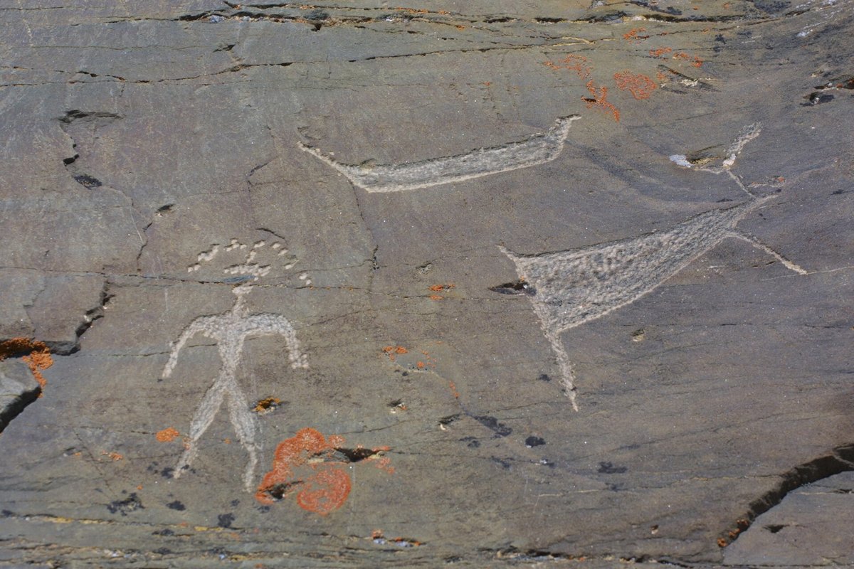
The first engravings were reported in 1965 by a geologist, Nikolai Samorukov, who was prospecting in the region. From 1967, the archaeologist Nikolai Dikov, a towering figure in the prehistoryPrehistoryThe span of human history before the invention of writing, from the Palaeolithic to the Metal Ages, known mainly through material remains.→ of the Russian Far East, began studying them systematically. In 1968 he excavated a hunters' camp at the foot of the cliffs, yielding the first clues about the people who made the engravings. His work, published in the early 1970s, brought the site to the attention of the whole scientific community.13
Other teams followed. In 2000 and again in 2005, expeditions led notably by M. V. Slobodzian of the Hermitage Museum and Ekaterina Devlet of the IA RAS surveyed the escarpment without finding any new site. Since 2005 the Institute of Archaeology has pursued research methodically, and since 2021, after a thirteen-year hiatus, a team led by Elena Levanova and Yuri Svoyski has carried out a complete digital survey of the site.13
Climbers in the service of archaeology
During the August 2026 season, the team chose to tackle sectors that nobody had been able to examine closely. Some panels, perched on overhangs or on the edge of unstable ledges, could only be reached with climbing equipment. Elsewhere, the researchers cleared blocks half-buried in scree, removed the lichens and soil masking the rock, and watched engraved surfaces appear in areas thought to be empty.12
The results are impressive. Thirty-one new decorated surfaces were identified, bringing the total number of documented surfaces on the Keeneikuul and Kychakvaams escarpment to 690. The Keeneikuul cliff, the heart of the site, alone accounts for 680. The eastern part of this main concentration, long thought to be poor in engravings, turned out to be densely decorated.12
Further on, the expedition surveyed more than ten kilometres of cliffs between two streams, in an area where the 2000 and 2005 missions had found nothing. This time the researchers identified a new rock art locality, named Keininei I, made up of nine engraved surfaces. Images now occupy all four main rock faces of the escarpment, separated from one another by streams. Far from being a single isolated panel, the Pegtymel emerges as a true engraved landscape, stretched along the river.1
Swimming reindeer, whales and sea hunts
What do these images tellTellAn artificial mound formed by the accumulation of successive layers of settlement remains at the same spot, typical of the Near East. Each destruction-rebuilding event adds a stratum.→ us? First, the daily life of Far North hunters, governed by the movements of the herds and the rhythm of the seasons. The most frequent scene shows reindeer caught as they swim across the river, pursued by men in boats who strike them with spears or harpoonsHarpoonA hunting and fishing weapon of reindeer antler or bone, fitted with barbs; an emblematic MagdalenianMagdalenianThe last great Upper Palaeolithic culture (c. 17,000–12,000 BC), the peak of cave art (Lascaux).→ object whose forms help date archaeological layers.→. This river-crossing hunting technique, in which hunters wait for herds at their most vulnerable moment, was practised by Arctic peoples into modern times.2
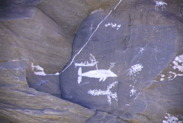
But the sea is never far away. Other panels show whales and seals, also hunted from boats. The bestiary further includes bears, wolves, Arctic foxes, birds and dogs, the indispensable companions of Arctic hunters.3 This twofold orientation, towards the tundra and towards the ocean, reflects a way of life entirely shaped by the seasons, in which people followed the reindeer in summer and autumn before turning to marine resources.2
Dating the ensemble relies mainly on the style of the figures and on artefacts found nearby. The engravings are generally attributed to the last centuries BCE and the first centuries CE, roughly two thousand years ago.24 The boats depicted, long and slender, recall the skin boats of the maritime cultures of the Bering Strait, which developed at precisely this time.
The mysterious mushroom-headed people
Yet the site owes its fame to other figures. On several panels appear human silhouettes, often female, whose heads are topped with a broad, rounded headdress shaped like a mushroom cap. Some seem to dance, others hold hands or accompany hunting scenes. For most specialists, these beings refer to the fly agaric (Amanita muscaria), a mushroom with hallucinogenic properties, and perhaps to ritual practices associated with it.24
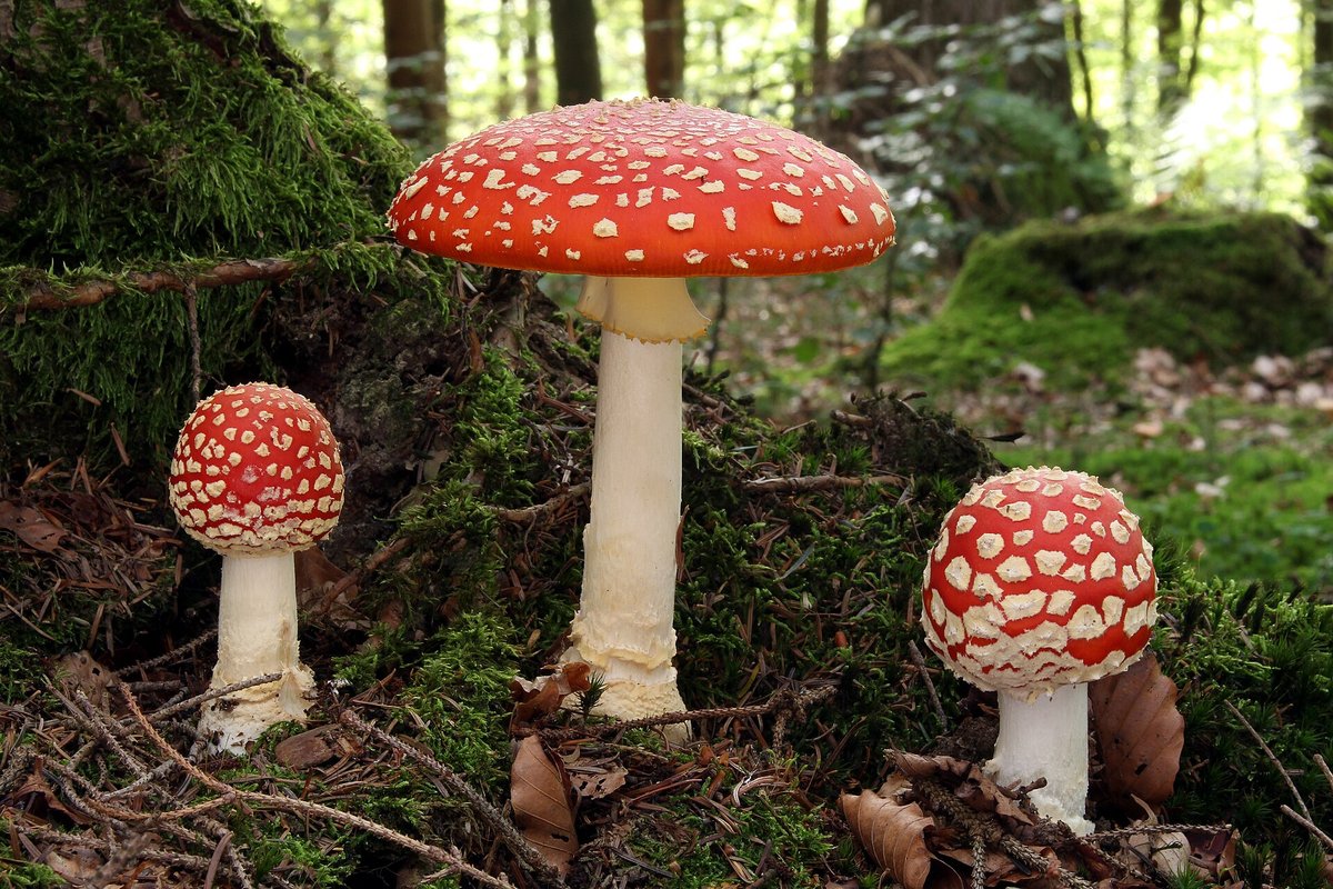
The hypothesis is far from fanciful. Accounts by 19th- and 20th-century ethnographers describe the ritual consumption of fly agaric among several peoples of north-eastern Siberia, including the Chukchi and the Koryak. The mushroom was associated with shamanismShamanismA set of beliefs and ritual practices based on communication between the living and a spirit world, mediated by a practitioner (the shaman) entering a trance state. The shamanic hypothesis has been proposed to interpret part of PalaeolithicPalaeolithicThe oldest and longest period of prehistory (c. 3.3 Ma–12,000 BC), defined by chipped stone tools and a hunter-gatherer way of life.→ parietal art.→, visions and journeys into the other world. In some oral traditions, "mushroom people" appear to intoxicated individuals to guide them through their visions.5 The Pegtymel figures may represent these spirits, or officiants in ritual costume. Dikov himself already saw them as illustrations of beliefs linked to the sacred mushroom.
If this reading is correct, the Pegtymel engravings would rank among the oldest known depictions of ritual fly agaric use in Siberia. They would bear witness to a continuity of belief over nearly two millennia, from the hunters who engraved these cliffs to the shamans observed by European travellers.
A digital survey accurate to the centimetre
Beyond the discoveries, the 2026 season marks the culmination of a documentation project launched in 2021. For the first time, researchers have a digital record of every known Pegtymel petroglyph. Each engraved surface has been located by precision geodetic positioning, photographed and modelled in high-resolution 3D. Drone photogrammetry surveys mapped the entire cliff line, and all the data have been integrated into a geographic information system.1
This approach changes the way the site can be read. 3D models and detailed maps show how the engravings respond to one another from one rock face to the next, and how they are organised in relation to streams, viewpoints over the river and the probable crossing points of the reindeer. It also allows the researchers to define the boundaries of the different rock art localities, Keeneikuul, Keininei and Ankapagrat.12
A second camp at the foot of the cliffs
The cliffs yielded more than images. Walking along the foot of the escarpment, the team picked up from the surface a point of bone or antler, perhaps a harpoon fragment, a pebble tool bearing flake scars, and a chalcedony scraper. These objects point to a second activity area, devoted to working bone and stone, located east of the camp Dikov excavated in 1968.1
The find matters because it reminds us that the engravings are not isolated in a wilderness. They belong to an inhabited landscape, where people knapped tools, prepared hides, repaired weapons and watched for passing herds. The place where people hunted was also where they engraved, perhaps to ensure success, to honour the spirits of the game or to pass on knowledge.2
A race against the frost
Time is pressing. In this Arctic environment, the rock undergoes freeze-thaw cycles every year that widen cracks and make rock surfaces burst. Lichens colonise the engravings, erosion gradually wipes them away, and vandalism, though rare in so remote a place, has already left its mark. "It is very important to create a virtual copy of each site in order to preserve them," Elena Levanova stressed as early as 2021.3
That is the whole point of the virtual museum now in preparation. Freely accessible, it will offer interactive 3D models of the engraved panels and a complete panoramic tour of the site. The reindeer and whale hunters of the Pegtymel, and their enigmatic mushroom-capped companions, will thus be open to all those who will never make it to Chukotka.1
The expedition was funded by a grant from the Russian Geographical Society, with logistical support from mining companies and local authorities, including the port of Pevek.1 Proof, if any were needed, that even at the ends of the earth archaeology remains a collective adventure. And that the best-explored cliffs can still hold surprises for anyone willing to hang from the end of a rope.
No comments yet. Be the first.